You are here: Home > Network List > TA - USArray Transportable Network (new EarthScope stations) Stations List
> Station KMSC Kings Mountain, Blacksburg, SC, USA > Earthquake Result Viewer
KMSC Kings Mountain, Blacksburg, SC, USA - Earthquake Result Viewer

| Earthquake location: |
Near Coast Of Central Chile |
| Earthquake latitude/longitude: |
-38.1/-73.3 |
| Earthquake time(UTC): |
2010/07/14 (195) 08:32:21 GMT |
| Earthquake Depth: |
22 km |
| Earthquake Magnitude: |
5.9 MB, 6.5 MS, 6.6 MW, 6.5 MW |
| Earthquake Catalog/Contributor: |
WHDF/NEIC |
|
| Network: |
TA USArray Transportable Network (new EarthScope stations) |
| Station: |
KMSC Kings Mountain, Blacksburg, SC, USA |
| Lat/Lon: |
35.14 N/81.33 W |
| Elevation: |
240 m |
|
| Distance: |
73.2 deg |
| Az: |
353.138 deg |
| Baz: |
173.393 deg |
| Ray Param: |
0.05312355 |
| Estimated Moho Depth: |
25.5 km |
| Estimated Crust Vp/Vs: |
2.04 |
| Assumed Crust Vp: |
6.419 km/s |
| Estimated Crust Vs: |
3.147 km/s |
| Estimated Crust Poisson's Ratio: |
0.34 |
|
| Radial Match: |
88.968414 % |
| Radial Bump: |
382 |
| Transverse Match: |
73.631294 % |
| Transverse Bump: |
400 |
| SOD ConfigId: |
319893 |
| Insert Time: |
2011-01-05 03:06:02.121 +0000 |
| GWidth: |
2.5 |
| Max Bumps: |
400 |
| Tol: |
0.001 |
|
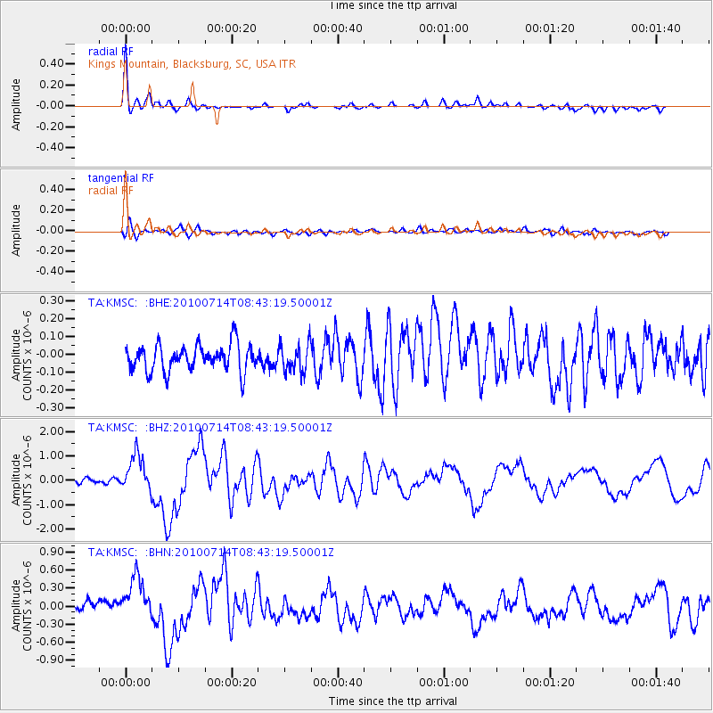
Signal To Noise
| Channel | StoN | STA | LTA |
| TA:KMSC: :BHZ:20100714T08:43:19.50001Z | 7.895105 | 7.5965625E-7 | 9.621864E-8 |
| TA:KMSC: :BHN:20100714T08:43:19.50001Z | 2.849993 | 3.9451487E-7 | 1.3842661E-7 |
| TA:KMSC: :BHE:20100714T08:43:19.50001Z | 1.0356673 | 7.723098E-8 | 7.4571226E-8 |
| Arrivals |
| Ps | 4.3 SECOND |
| PpPs | 12 SECOND |
| PsPs/PpSs | 16 SECOND |


