You are here: Home > Network List > TA - USArray Transportable Network (new EarthScope stations) Stations List
> Station J24A Dixon Ranch, Lance Creek, WY, USA > Earthquake Result Viewer
J24A Dixon Ranch, Lance Creek, WY, USA - Earthquake Result Viewer
| Earthquake location: |
Near Coast Of Central Chile |
| Earthquake latitude/longitude: |
-38.1/-73.3 |
| Earthquake time(UTC): |
2010/07/14 (195) 08:32:21 GMT |
| Earthquake Depth: |
22 km |
| Earthquake Magnitude: |
5.9 MB, 6.5 MS, 6.6 MW, 6.5 MW |
| Earthquake Catalog/Contributor: |
WHDF/NEIC |
|
| Network: |
TA USArray Transportable Network (new EarthScope stations) |
| Station: |
J24A Dixon Ranch, Lance Creek, WY, USA |
| Lat/Lon: |
43.33 N/104.66 W |
| Elevation: |
1315 m |
|
| Distance: |
85.9 deg |
| Az: |
337.627 deg |
| Baz: |
155.687 deg |
| Ray Param: |
0.044433948 |
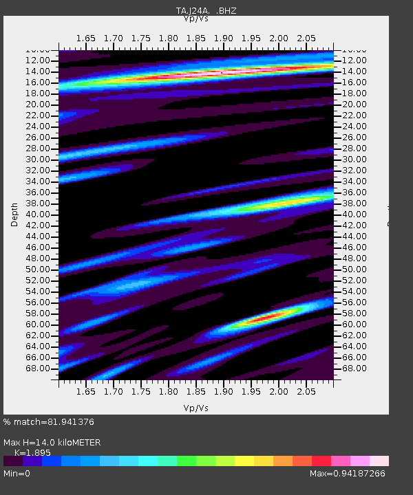
| Estimated Moho Depth: |
14.0 km |
| Estimated Crust Vp/Vs: |
1.89 |
| Assumed Crust Vp: |
6.159 km/s |
| Estimated Crust Vs: |
3.25 km/s |
| Estimated Crust Poisson's Ratio: |
0.31 |
|
| Radial Match: |
81.941376 % |
| Radial Bump: |
400 |
| Transverse Match: |
71.9239 % |
| Transverse Bump: |
400 |
| SOD ConfigId: |
319893 |
| Insert Time: |
2011-01-05 03:06:50.862 +0000 |
| GWidth: |
2.5 |
| Max Bumps: |
400 |
| Tol: |
0.001 |
|
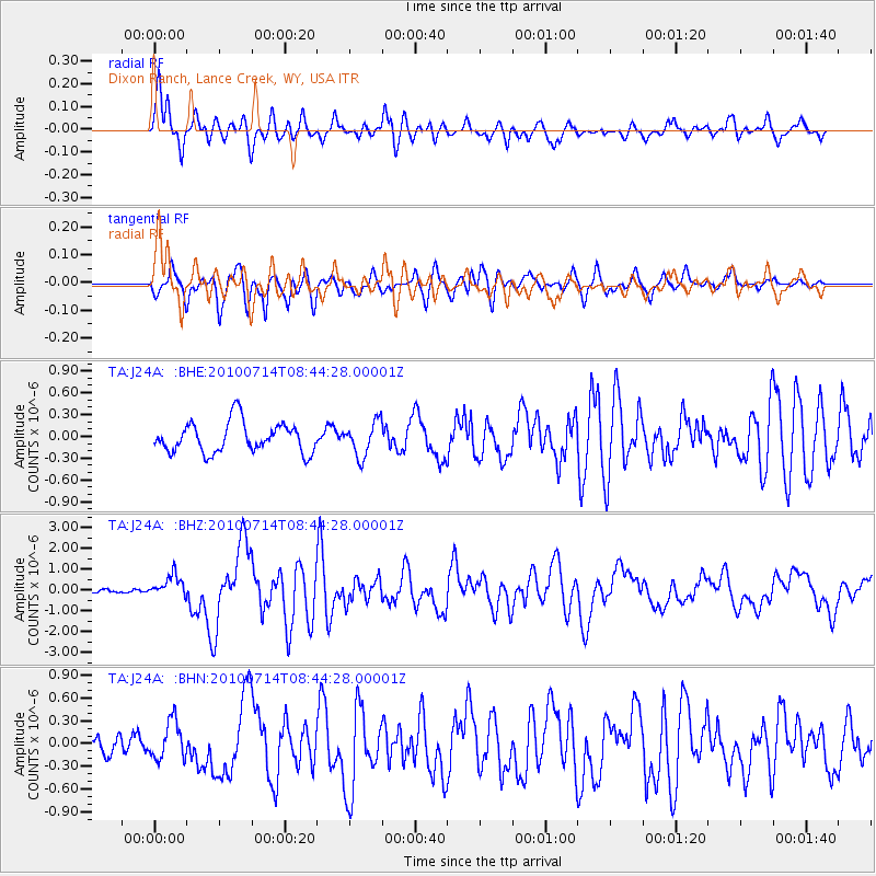
Signal To Noise
| Channel | StoN | STA | LTA |
| TA:J24A: :BHZ:20100714T08:44:28.00001Z | 4.088031 | 5.364098E-7 | 1.3121472E-7 |
| TA:J24A: :BHN:20100714T08:44:28.00001Z | 1.373585 | 2.5348044E-7 | 1.8453932E-7 |
| TA:J24A: :BHE:20100714T08:44:28.00001Z | 1.1368529 | 2.3481596E-7 | 2.0654912E-7 |
| Arrivals |
| Ps | 2.1 SECOND |
| PpPs | 6.4 SECOND |
| PsPs/PpSs | 8.5 SECOND |


