You are here: Home > Network List > TA - USArray Transportable Network (new EarthScope stations) Stations List
> Station N27A Anderson Farm, Haxtun, CO, USA > Earthquake Result Viewer
N27A Anderson Farm, Haxtun, CO, USA - Earthquake Result Viewer
| Earthquake location: |
Near Coast Of Central Chile |
| Earthquake latitude/longitude: |
-38.1/-73.3 |
| Earthquake time(UTC): |
2010/07/14 (195) 08:32:21 GMT |
| Earthquake Depth: |
22 km |
| Earthquake Magnitude: |
5.9 MB, 6.5 MS, 6.6 MW, 6.5 MW |
| Earthquake Catalog/Contributor: |
WHDF/NEIC |
|
| Network: |
TA USArray Transportable Network (new EarthScope stations) |
| Station: |
N27A Anderson Farm, Haxtun, CO, USA |
| Lat/Lon: |
40.81 N/102.54 W |
| Elevation: |
1228 m |
|
| Distance: |
82.9 deg |
| Az: |
338.07 deg |
| Baz: |
157.149 deg |
| Ray Param: |
0.046526797 |
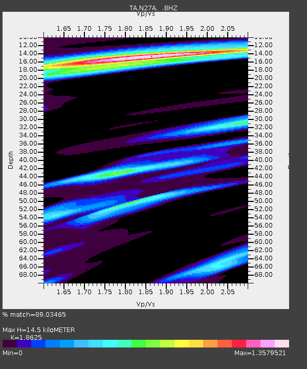
| Estimated Moho Depth: |
14.5 km |
| Estimated Crust Vp/Vs: |
1.86 |
| Assumed Crust Vp: |
6.483 km/s |
| Estimated Crust Vs: |
3.481 km/s |
| Estimated Crust Poisson's Ratio: |
0.30 |
|
| Radial Match: |
89.03465 % |
| Radial Bump: |
330 |
| Transverse Match: |
66.33063 % |
| Transverse Bump: |
400 |
| SOD ConfigId: |
319893 |
| Insert Time: |
2011-01-05 03:08:41.963 +0000 |
| GWidth: |
2.5 |
| Max Bumps: |
400 |
| Tol: |
0.001 |
|
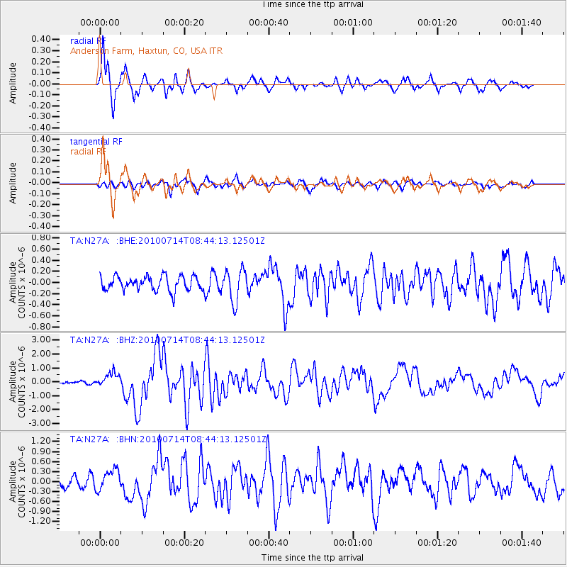
Signal To Noise
| Channel | StoN | STA | LTA |
| TA:N27A: :BHZ:20100714T08:44:13.12501Z | 4.871667 | 5.2088217E-7 | 1.0692073E-7 |
| TA:N27A: :BHN:20100714T08:44:13.12501Z | 1.9477115 | 3.092579E-7 | 1.5878014E-7 |
| TA:N27A: :BHE:20100714T08:44:13.12501Z | 2.2951858 | 2.9327546E-7 | 1.2777852E-7 |
| Arrivals |
| Ps | 2.0 SECOND |
| PpPs | 6.2 SECOND |
| PsPs/PpSs | 8.2 SECOND |


