You are here: Home > Network List > TA - USArray Transportable Network (new EarthScope stations) Stations List
> Station O27A Beecher Island, Eckley, CO, USA > Earthquake Result Viewer
O27A Beecher Island, Eckley, CO, USA - Earthquake Result Viewer
| Earthquake location: |
Near Coast Of Central Chile |
| Earthquake latitude/longitude: |
-38.1/-73.3 |
| Earthquake time(UTC): |
2010/07/14 (195) 08:32:21 GMT |
| Earthquake Depth: |
22 km |
| Earthquake Magnitude: |
5.9 MB, 6.5 MS, 6.6 MW, 6.5 MW |
| Earthquake Catalog/Contributor: |
WHDF/NEIC |
|
| Network: |
TA USArray Transportable Network (new EarthScope stations) |
| Station: |
O27A Beecher Island, Eckley, CO, USA |
| Lat/Lon: |
40.19 N/102.48 W |
| Elevation: |
1206 m |
|
| Distance: |
82.3 deg |
| Az: |
337.869 deg |
| Baz: |
157.16 deg |
| Ray Param: |
0.046932463 |
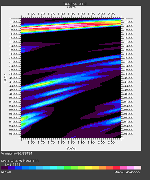
| Estimated Moho Depth: |
13.75 km |
| Estimated Crust Vp/Vs: |
1.77 |
| Assumed Crust Vp: |
6.483 km/s |
| Estimated Crust Vs: |
3.668 km/s |
| Estimated Crust Poisson's Ratio: |
0.26 |
|
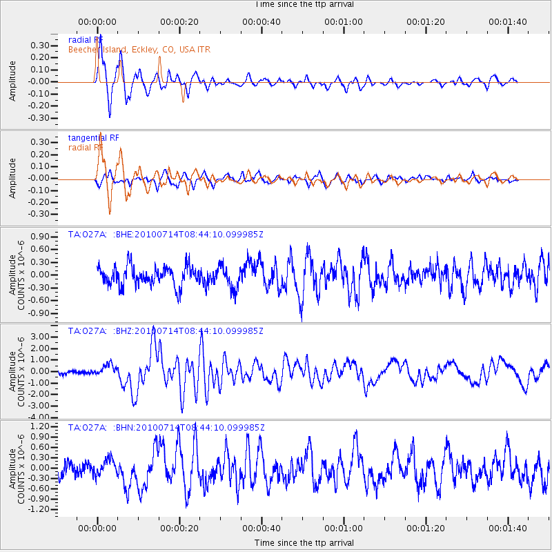
| Radial Match: |
86.83934 % |
| Radial Bump: |
394 |
| Transverse Match: |
55.993523 % |
| Transverse Bump: |
400 |
| SOD ConfigId: |
319893 |
| Insert Time: |
2011-01-05 03:09:05.615 +0000 |
| GWidth: |
2.5 |
| Max Bumps: |
400 |
| Tol: |
0.001 |
|
Signal To Noise
| Channel | StoN | STA | LTA |
| TA:O27A: :BHZ:20100714T08:44:10.099985Z | 4.853898 | 5.1270706E-7 | 1.05627905E-7 |
| TA:O27A: :BHN:20100714T08:44:10.099985Z | 1.0893183 | 2.2995437E-7 | 2.1109935E-7 |
| TA:O27A: :BHE:20100714T08:44:10.099985Z | 1.1814259 | 2.6312946E-7 | 2.2272195E-7 |
| Arrivals |
| Ps | 1.7 SECOND |
| PpPs | 5.7 SECOND |
| PsPs/PpSs | 7.4 SECOND |


