You are here: Home > Network List > TA - USArray Transportable Network (new EarthScope stations) Stations List
> Station N26A Koester Ranch, Padroni, CO, USA > Earthquake Result Viewer
N26A Koester Ranch, Padroni, CO, USA - Earthquake Result Viewer

| Earthquake location: |
Near Coast Of Central Chile |
| Earthquake latitude/longitude: |
-38.1/-73.3 |
| Earthquake time(UTC): |
2010/07/14 (195) 08:32:21 GMT |
| Earthquake Depth: |
22 km |
| Earthquake Magnitude: |
5.9 MB, 6.5 MS, 6.6 MW, 6.5 MW |
| Earthquake Catalog/Contributor: |
WHDF/NEIC |
|
| Network: |
TA USArray Transportable Network (new EarthScope stations) |
| Station: |
N26A Koester Ranch, Padroni, CO, USA |
| Lat/Lon: |
40.83 N/103.22 W |
| Elevation: |
1284 m |
|
| Distance: |
83.2 deg |
| Az: |
337.596 deg |
| Baz: |
156.645 deg |
| Ray Param: |
0.04637054 |
| Estimated Moho Depth: |
18.25 km |
| Estimated Crust Vp/Vs: |
1.72 |
| Assumed Crust Vp: |
6.483 km/s |
| Estimated Crust Vs: |
3.78 km/s |
| Estimated Crust Poisson's Ratio: |
0.24 |
|
| Radial Match: |
85.90721 % |
| Radial Bump: |
256 |
| Transverse Match: |
53.08372 % |
| Transverse Bump: |
400 |
| SOD ConfigId: |
319893 |
| Insert Time: |
2011-01-05 03:09:08.500 +0000 |
| GWidth: |
2.5 |
| Max Bumps: |
400 |
| Tol: |
0.001 |
|
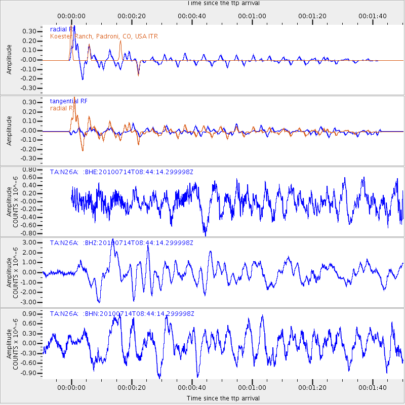
Signal To Noise
| Channel | StoN | STA | LTA |
| TA:N26A: :BHZ:20100714T08:44:14.299998Z | 4.254792 | 5.004364E-7 | 1.1761712E-7 |
| TA:N26A: :BHN:20100714T08:44:14.299998Z | 1.3207885 | 2.0041843E-7 | 1.5174149E-7 |
| TA:N26A: :BHE:20100714T08:44:14.299998Z | 1.312406 | 2.3020586E-7 | 1.7540751E-7 |
| Arrivals |
| Ps | 2.1 SECOND |
| PpPs | 7.4 SECOND |
| PsPs/PpSs | 9.5 SECOND |


