You are here: Home > Network List > TA - USArray Transportable Network (new EarthScope stations) Stations List
> Station Z29A Hungry Hill Ranch, Wilson, TX, USA > Earthquake Result Viewer
Z29A Hungry Hill Ranch, Wilson, TX, USA - Earthquake Result Viewer
| Earthquake location: |
Near Coast Of Central Chile |
| Earthquake latitude/longitude: |
-38.1/-73.3 |
| Earthquake time(UTC): |
2010/07/14 (195) 08:32:21 GMT |
| Earthquake Depth: |
22 km |
| Earthquake Magnitude: |
5.9 MB, 6.5 MS, 6.6 MW, 6.5 MW |
| Earthquake Catalog/Contributor: |
WHDF/NEIC |
|
| Network: |
TA USArray Transportable Network (new EarthScope stations) |
| Station: |
Z29A Hungry Hill Ranch, Wilson, TX, USA |
| Lat/Lon: |
33.26 N/101.71 W |
| Elevation: |
938 m |
|
| Distance: |
75.7 deg |
| Az: |
335.722 deg |
| Baz: |
157.212 deg |
| Ray Param: |
0.051452577 |
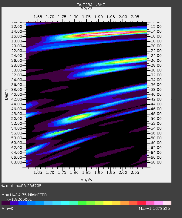
| Estimated Moho Depth: |
14.75 km |
| Estimated Crust Vp/Vs: |
1.92 |
| Assumed Crust Vp: |
6.426 km/s |
| Estimated Crust Vs: |
3.347 km/s |
| Estimated Crust Poisson's Ratio: |
0.31 |
|
| Radial Match: |
88.286705 % |
| Radial Bump: |
400 |
| Transverse Match: |
64.69026 % |
| Transverse Bump: |
400 |
| SOD ConfigId: |
319893 |
| Insert Time: |
2011-01-05 03:10:06.854 +0000 |
| GWidth: |
2.5 |
| Max Bumps: |
400 |
| Tol: |
0.001 |
|

Signal To Noise
| Channel | StoN | STA | LTA |
| TA:Z29A: :BHZ:20100714T08:43:34.00001Z | 7.2996054 | 5.6581905E-7 | 7.7513654E-8 |
| TA:Z29A: :BHN:20100714T08:43:34.00001Z | 4.082438 | 4.6494307E-7 | 1.1388858E-7 |
| TA:Z29A: :BHE:20100714T08:43:34.00001Z | 2.191047 | 1.7545727E-7 | 8.00792E-8 |
| Arrivals |
| Ps | 2.2 SECOND |
| PpPs | 6.5 SECOND |
| PsPs/PpSs | 8.7 SECOND |


