You are here: Home > Network List > AV - Alaska Volcano Observatory Stations List
> Station MAPS Pakushin Southeast, Makushin Volcano, Alaska > Earthquake Result Viewer
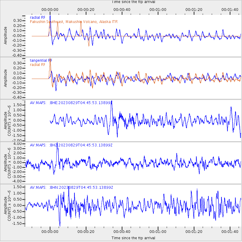
MAPS Pakushin Southeast, Makushin Volcano, Alaska - Earthquake Result Viewer
*The percent match for this event was below the threshold and hence no stack was calculated.
| Earthquake location: |
Banda Sea |
| Earthquake latitude/longitude: |
-5.6/130.0 |
| Earthquake time(UTC): |
2023/08/29 (241) 04:34:42 GMT |
| Earthquake Depth: |
203 km |
| Earthquake Magnitude: |
5.9 mww |
| Earthquake Catalog/Contributor: |
NEIC PDE/us |
|
| Network: |
AV Alaska Volcano Observatory |
| Station: |
MAPS Pakushin Southeast, Makushin Volcano, Alaska |
| Lat/Lon: |
53.81 N/166.94 W |
| Elevation: |
333 m |
|
| Distance: |
79.1 deg |
| Az: |
32.593 deg |
| Baz: |
244.696 deg |
| Ray Param: |
$rayparam |
*The percent match for this event was below the threshold and hence was not used in the summary stack. |
|
| Radial Match: |
66.648 % |
| Radial Bump: |
400 |
| Transverse Match: |
58.9729 % |
| Transverse Bump: |
400 |
| SOD ConfigId: |
31937991 |
| Insert Time: |
2023-09-12 04:41:14.706 +0000 |
| GWidth: |
2.5 |
| Max Bumps: |
400 |
| Tol: |
0.001 |
|
Signal To Noise
| Channel | StoN | STA | LTA |
| AV:MAPS: :BHZ:20230829T04:45:53.13899Z | 2.8207626 | 1.6900357E-6 | 5.991414E-7 |
| AV:MAPS: :BHN:20230829T04:45:53.13899Z | 1.0463849 | 3.2845008E-7 | 3.1389033E-7 |
| AV:MAPS: :BHE:20230829T04:45:53.13899Z | 3.2974102 | 8.600041E-7 | 2.60812E-7 |
| Arrivals |
| Ps | |
| PpPs | |
| PsPs/PpSs | |


