You are here: Home > Network List > TA - USArray Transportable Network (new EarthScope stations) Stations List
> Station 732A Laxson Ranch, Crystal City, TX, USA > Earthquake Result Viewer
732A Laxson Ranch, Crystal City, TX, USA - Earthquake Result Viewer

| Earthquake location: |
Near Coast Of Central Chile |
| Earthquake latitude/longitude: |
-38.1/-73.3 |
| Earthquake time(UTC): |
2010/07/14 (195) 08:32:21 GMT |
| Earthquake Depth: |
22 km |
| Earthquake Magnitude: |
5.9 MB, 6.5 MS, 6.6 MW, 6.5 MW |
| Earthquake Catalog/Contributor: |
WHDF/NEIC |
|
| Network: |
TA USArray Transportable Network (new EarthScope stations) |
| Station: |
732A Laxson Ranch, Crystal City, TX, USA |
| Lat/Lon: |
28.73 N/99.97 W |
| Elevation: |
178 m |
|
| Distance: |
71.0 deg |
| Az: |
335.365 deg |
| Baz: |
158.0 deg |
| Ray Param: |
0.05459852 |
| Estimated Moho Depth: |
25.0 km |
| Estimated Crust Vp/Vs: |
2.08 |
| Assumed Crust Vp: |
6.347 km/s |
| Estimated Crust Vs: |
3.059 km/s |
| Estimated Crust Poisson's Ratio: |
0.35 |
|
| Radial Match: |
94.351974 % |
| Radial Bump: |
377 |
| Transverse Match: |
84.42316 % |
| Transverse Bump: |
398 |
| SOD ConfigId: |
319893 |
| Insert Time: |
2011-01-05 03:11:21.607 +0000 |
| GWidth: |
2.5 |
| Max Bumps: |
400 |
| Tol: |
0.001 |
|
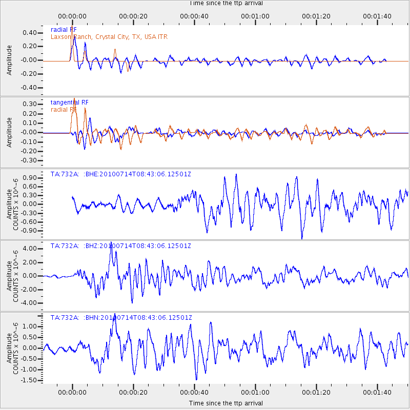
Signal To Noise
| Channel | StoN | STA | LTA |
| TA:732A: :BHZ:20100714T08:43:06.12501Z | 3.9331832 | 4.361614E-7 | 1.1089273E-7 |
| TA:732A: :BHN:20100714T08:43:06.12501Z | 1.205774 | 1.5429988E-7 | 1.279675E-7 |
| TA:732A: :BHE:20100714T08:43:06.12501Z | 0.68488586 | 8.9787754E-8 | 1.3109886E-7 |
| Arrivals |
| Ps | 4.4 SECOND |
| PpPs | 12 SECOND |
| PsPs/PpSs | 16 SECOND |


