You are here: Home > Network List > IM - International Miscellaneous Stations Stations List
> Station MK31 Makanchi Array Site 31, Kazakhstan > Earthquake Result Viewer
MK31 Makanchi Array Site 31, Kazakhstan - Earthquake Result Viewer
| Earthquake location: |
Banda Sea |
| Earthquake latitude/longitude: |
-5.6/130.0 |
| Earthquake time(UTC): |
2023/08/29 (241) 04:34:42 GMT |
| Earthquake Depth: |
203 km |
| Earthquake Magnitude: |
5.9 mww |
| Earthquake Catalog/Contributor: |
NEIC PDE/us |
|
| Network: |
IM International Miscellaneous Stations |
| Station: |
MK31 Makanchi Array Site 31, Kazakhstan |
| Lat/Lon: |
46.79 N/82.29 E |
| Elevation: |
618 m |
|
| Distance: |
67.0 deg |
| Az: |
326.509 deg |
| Baz: |
126.925 deg |
| Ray Param: |
0.056657966 |
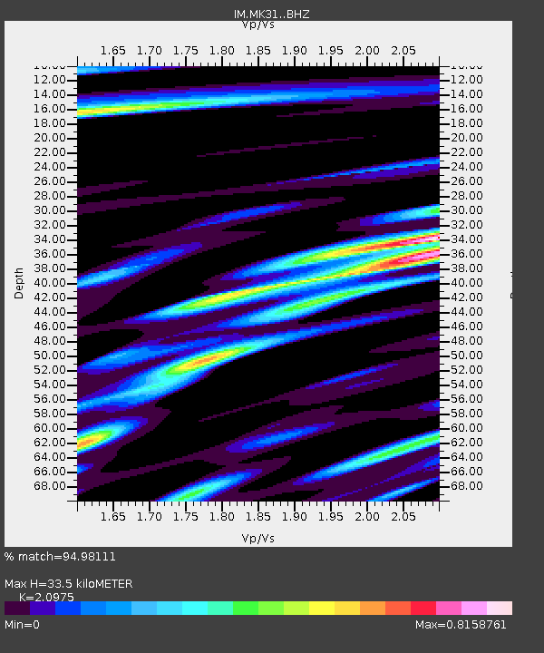
| Estimated Moho Depth: |
33.5 km |
| Estimated Crust Vp/Vs: |
2.10 |
| Assumed Crust Vp: |
6.688 km/s |
| Estimated Crust Vs: |
3.189 km/s |
| Estimated Crust Poisson's Ratio: |
0.35 |
|
| Radial Match: |
94.98111 % |
| Radial Bump: |
327 |
| Transverse Match: |
88.7109 % |
| Transverse Bump: |
400 |
| SOD ConfigId: |
31937991 |
| Insert Time: |
2023-09-12 04:44:37.466 +0000 |
| GWidth: |
2.5 |
| Max Bumps: |
400 |
| Tol: |
0.001 |
|

Signal To Noise
| Channel | StoN | STA | LTA |
| IM:MK31: :BHZ:20230829T04:44:42.698988Z | 50.72781 | 7.428491E-8 | 1.4643824E-9 |
| IM:MK31: :BHN:20230829T04:44:42.698988Z | 14.168992 | 1.7690192E-8 | 1.2485145E-9 |
| IM:MK31: :BHE:20230829T04:44:42.698988Z | 28.579174 | 3.179409E-8 | 1.1124917E-9 |
| Arrivals |
| Ps | 5.7 SECOND |
| PpPs | 15 SECOND |
| PsPs/PpSs | 21 SECOND |


