You are here: Home > Network List > TM - Thai Seismic Monitoring Network Stations List
> Station PANO PANO staion > Earthquake Result Viewer
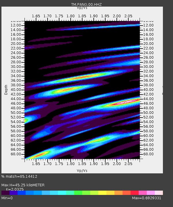
PANO PANO staion - Earthquake Result Viewer
| Earthquake location: |
Banda Sea |
| Earthquake latitude/longitude: |
-5.6/130.0 |
| Earthquake time(UTC): |
2023/08/29 (241) 04:34:42 GMT |
| Earthquake Depth: |
203 km |
| Earthquake Magnitude: |
5.9 mww |
| Earthquake Catalog/Contributor: |
NEIC PDE/us |
|
| Network: |
TM Thai Seismic Monitoring Network |
| Station: |
PANO PANO staion |
| Lat/Lon: |
17.15 N/104.61 E |
| Elevation: |
136 m |
|
| Distance: |
33.7 deg |
| Az: |
312.47 deg |
| Baz: |
129.832 deg |
| Ray Param: |
0.07739725 |
| Estimated Moho Depth: |
45.25 km |
| Estimated Crust Vp/Vs: |
2.03 |
| Assumed Crust Vp: |
6.498 km/s |
| Estimated Crust Vs: |
3.197 km/s |
| Estimated Crust Poisson's Ratio: |
0.34 |
|
| Radial Match: |
85.14412 % |
| Radial Bump: |
348 |
| Transverse Match: |
77.21867 % |
| Transverse Bump: |
400 |
| SOD ConfigId: |
31937991 |
| Insert Time: |
2023-09-12 04:47:13.823 +0000 |
| GWidth: |
2.5 |
| Max Bumps: |
400 |
| Tol: |
0.001 |
|

Signal To Noise
| Channel | StoN | STA | LTA |
| TM:PANO:00:HHZ:20230829T04:40:34.164991Z | 23.453022 | 5.266245E-7 | 2.245444E-8 |
| TM:PANO:00:HHN:20230829T04:40:34.164991Z | 1.3021157 | 3.039736E-8 | 2.3344592E-8 |
| TM:PANO:00:HHE:20230829T04:40:34.164991Z | 4.539206 | 9.4074366E-8 | 2.072485E-8 |
| Arrivals |
| Ps | 7.7 SECOND |
| PpPs | 20 SECOND |
| PsPs/PpSs | 27 SECOND |


