You are here: Home > Network List > TA - USArray Transportable Network (new EarthScope stations) Stations List
> Station U30A WK&E Inc., Balko, OK, USA > Earthquake Result Viewer
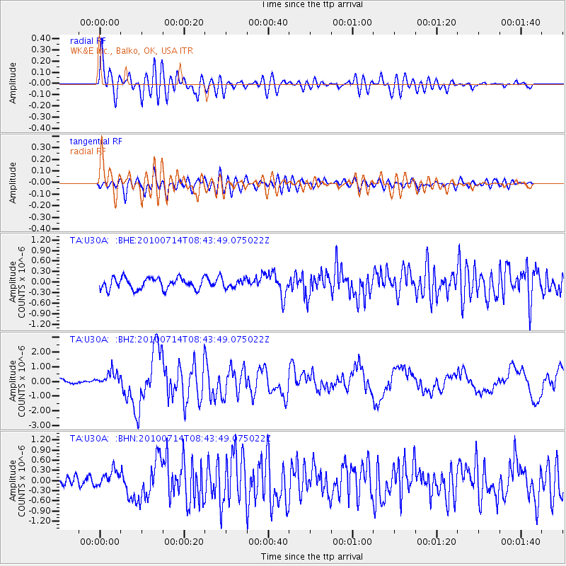
U30A WK&E Inc., Balko, OK, USA - Earthquake Result Viewer

| Earthquake location: |
Near Coast Of Central Chile |
| Earthquake latitude/longitude: |
-38.1/-73.3 |
| Earthquake time(UTC): |
2010/07/14 (195) 08:32:21 GMT |
| Earthquake Depth: |
22 km |
| Earthquake Magnitude: |
5.9 MB, 6.5 MS, 6.6 MW, 6.5 MW |
| Earthquake Catalog/Contributor: |
WHDF/NEIC |
|
| Network: |
TA USArray Transportable Network (new EarthScope stations) |
| Station: |
U30A WK&E Inc., Balko, OK, USA |
| Lat/Lon: |
36.53 N/100.65 W |
| Elevation: |
881 m |
|
| Distance: |
78.4 deg |
| Az: |
337.814 deg |
| Baz: |
158.281 deg |
| Ray Param: |
0.049634058 |
| Estimated Moho Depth: |
28.25 km |
| Estimated Crust Vp/Vs: |
2.06 |
| Assumed Crust Vp: |
6.483 km/s |
| Estimated Crust Vs: |
3.147 km/s |
| Estimated Crust Poisson's Ratio: |
0.35 |
|
| Radial Match: |
85.214554 % |
| Radial Bump: |
400 |
| Transverse Match: |
68.49976 % |
| Transverse Bump: |
400 |
| SOD ConfigId: |
319893 |
| Insert Time: |
2011-01-05 03:13:34.586 +0000 |
| GWidth: |
2.5 |
| Max Bumps: |
400 |
| Tol: |
0.001 |
|
Signal To Noise
| Channel | StoN | STA | LTA |
| TA:U30A: :BHZ:20100714T08:43:49.075022Z | 3.1181676 | 5.052766E-7 | 1.6204281E-7 |
| TA:U30A: :BHN:20100714T08:43:49.075022Z | 1.7508901 | 2.3697643E-7 | 1.3534626E-7 |
| TA:U30A: :BHE:20100714T08:43:49.075022Z | 0.7328552 | 1.1799245E-7 | 1.6100377E-7 |
| Arrivals |
| Ps | 4.7 SECOND |
| PpPs | 13 SECOND |
| PsPs/PpSs | 18 SECOND |


