You are here: Home > Network List > TA - USArray Transportable Network (new EarthScope stations) Stations List
> Station U27A Thompson Grove, Rita Blanca Nat Grassland, TX, USA > Earthquake Result Viewer
U27A Thompson Grove, Rita Blanca Nat Grassland, TX, USA - Earthquake Result Viewer
| Earthquake location: |
Near Coast Of Central Chile |
| Earthquake latitude/longitude: |
-38.1/-73.3 |
| Earthquake time(UTC): |
2010/07/14 (195) 08:32:21 GMT |
| Earthquake Depth: |
22 km |
| Earthquake Magnitude: |
5.9 MB, 6.5 MS, 6.6 MW, 6.5 MW |
| Earthquake Catalog/Contributor: |
WHDF/NEIC |
|
| Network: |
TA USArray Transportable Network (new EarthScope stations) |
| Station: |
U27A Thompson Grove, Rita Blanca Nat Grassland, TX, USA |
| Lat/Lon: |
36.42 N/102.82 W |
| Elevation: |
1342 m |
|
| Distance: |
79.0 deg |
| Az: |
336.121 deg |
| Baz: |
156.663 deg |
| Ray Param: |
0.049247704 |
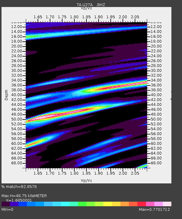
| Estimated Moho Depth: |
48.75 km |
| Estimated Crust Vp/Vs: |
1.69 |
| Assumed Crust Vp: |
6.306 km/s |
| Estimated Crust Vs: |
3.742 km/s |
| Estimated Crust Poisson's Ratio: |
0.23 |
|
| Radial Match: |
92.8578 % |
| Radial Bump: |
341 |
| Transverse Match: |
75.232216 % |
| Transverse Bump: |
400 |
| SOD ConfigId: |
319893 |
| Insert Time: |
2011-01-05 03:14:34.804 +0000 |
| GWidth: |
2.5 |
| Max Bumps: |
400 |
| Tol: |
0.001 |
|
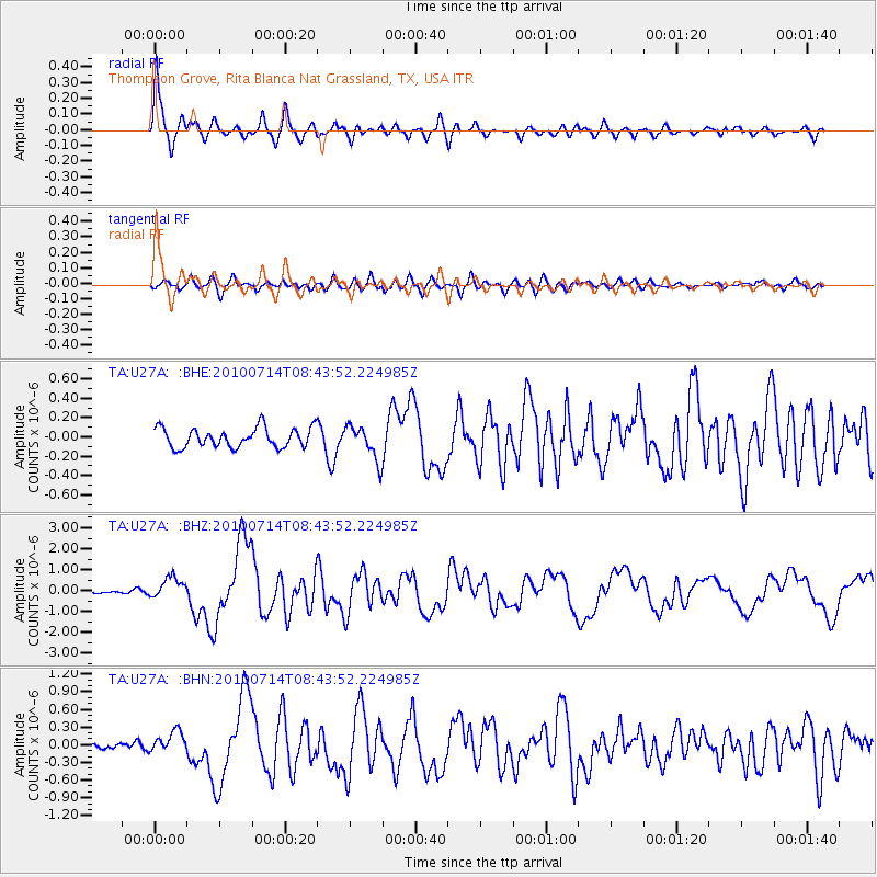
Signal To Noise
| Channel | StoN | STA | LTA |
| TA:U27A: :BHZ:20100714T08:43:52.224985Z | 5.3157735 | 5.037639E-7 | 9.476775E-8 |
| TA:U27A: :BHN:20100714T08:43:52.224985Z | 2.2443933 | 1.8391816E-7 | 8.194559E-8 |
| TA:U27A: :BHE:20100714T08:43:52.224985Z | 1.7615044 | 1.769923E-7 | 1.00477926E-7 |
| Arrivals |
| Ps | 5.5 SECOND |
| PpPs | 20 SECOND |
| PsPs/PpSs | 26 SECOND |


