You are here: Home > Network List > TA - USArray Transportable Network (new EarthScope stations) Stations List
> Station H25A Fruitdale, SD, USA > Earthquake Result Viewer
H25A Fruitdale, SD, USA - Earthquake Result Viewer
| Earthquake location: |
Near Coast Of Central Chile |
| Earthquake latitude/longitude: |
-38.1/-73.3 |
| Earthquake time(UTC): |
2010/07/14 (195) 08:32:21 GMT |
| Earthquake Depth: |
22 km |
| Earthquake Magnitude: |
5.9 MB, 6.5 MS, 6.6 MW, 6.5 MW |
| Earthquake Catalog/Contributor: |
WHDF/NEIC |
|
| Network: |
TA USArray Transportable Network (new EarthScope stations) |
| Station: |
H25A Fruitdale, SD, USA |
| Lat/Lon: |
44.62 N/103.60 W |
| Elevation: |
942 m |
|
| Distance: |
86.7 deg |
| Az: |
338.854 deg |
| Baz: |
156.501 deg |
| Ray Param: |
0.043811265 |
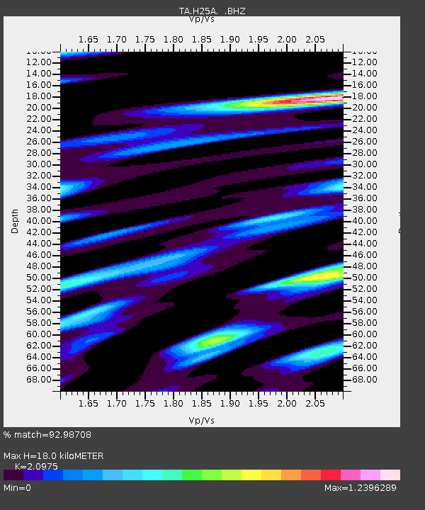
| Estimated Moho Depth: |
18.0 km |
| Estimated Crust Vp/Vs: |
2.10 |
| Assumed Crust Vp: |
6.242 km/s |
| Estimated Crust Vs: |
2.976 km/s |
| Estimated Crust Poisson's Ratio: |
0.35 |
|
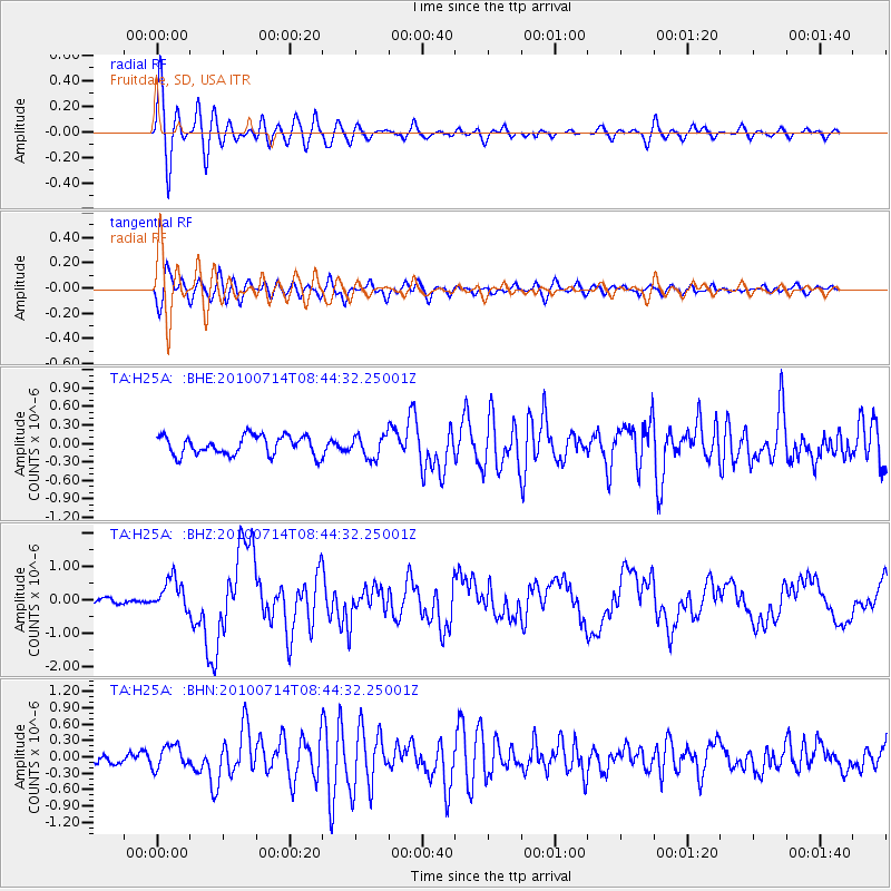
| Radial Match: |
92.98708 % |
| Radial Bump: |
400 |
| Transverse Match: |
82.013756 % |
| Transverse Bump: |
400 |
| SOD ConfigId: |
319893 |
| Insert Time: |
2011-01-05 03:17:42.091 +0000 |
| GWidth: |
2.5 |
| Max Bumps: |
400 |
| Tol: |
0.001 |
|
Signal To Noise
| Channel | StoN | STA | LTA |
| TA:H25A: :BHZ:20100714T08:44:32.25001Z | 7.2382326 | 4.7398652E-7 | 6.548374E-8 |
| TA:H25A: :BHN:20100714T08:44:32.25001Z | 1.8695838 | 2.0818293E-7 | 1.1135255E-7 |
| TA:H25A: :BHE:20100714T08:44:32.25001Z | 1.1646125 | 1.8055525E-7 | 1.550346E-7 |
| Arrivals |
| Ps | 3.2 SECOND |
| PpPs | 8.8 SECOND |
| PsPs/PpSs | 12 SECOND |


