You are here: Home > Network List > TA - USArray Transportable Network (new EarthScope stations) Stations List
> Station F30A Leola, SD, USA > Earthquake Result Viewer
F30A Leola, SD, USA - Earthquake Result Viewer
| Earthquake location: |
Near Coast Of Central Chile |
| Earthquake latitude/longitude: |
-38.1/-73.3 |
| Earthquake time(UTC): |
2010/07/14 (195) 08:32:21 GMT |
| Earthquake Depth: |
22 km |
| Earthquake Magnitude: |
5.9 MB, 6.5 MS, 6.6 MW, 6.5 MW |
| Earthquake Catalog/Contributor: |
WHDF/NEIC |
|
| Network: |
TA USArray Transportable Network (new EarthScope stations) |
| Station: |
F30A Leola, SD, USA |
| Lat/Lon: |
45.84 N/99.03 W |
| Elevation: |
601 m |
|
| Distance: |
86.7 deg |
| Az: |
342.31 deg |
| Baz: |
159.937 deg |
| Ray Param: |
0.043864213 |
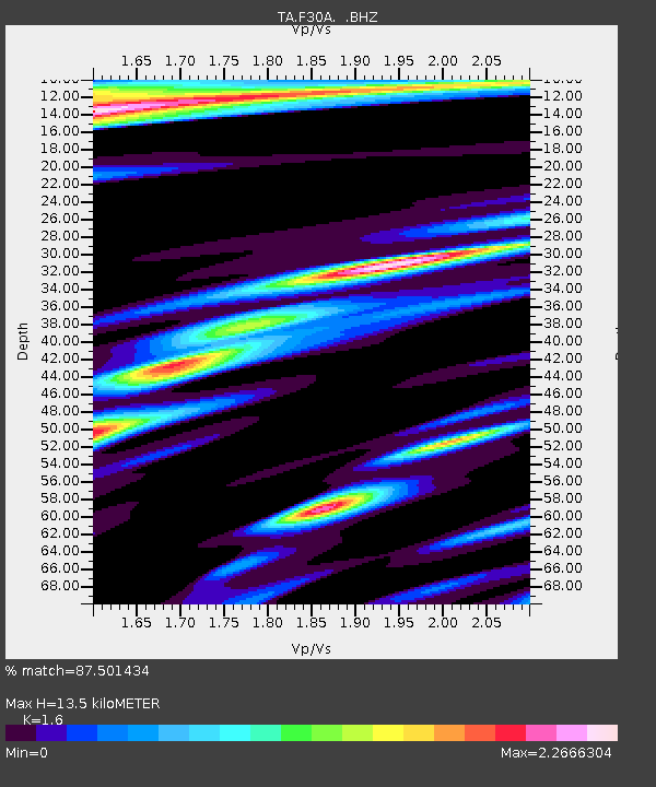
| Estimated Moho Depth: |
13.5 km |
| Estimated Crust Vp/Vs: |
1.60 |
| Assumed Crust Vp: |
6.53 km/s |
| Estimated Crust Vs: |
4.082 km/s |
| Estimated Crust Poisson's Ratio: |
0.18 |
|
| Radial Match: |
87.501434 % |
| Radial Bump: |
400 |
| Transverse Match: |
71.821686 % |
| Transverse Bump: |
400 |
| SOD ConfigId: |
319893 |
| Insert Time: |
2011-01-05 03:20:40.284 +0000 |
| GWidth: |
2.5 |
| Max Bumps: |
400 |
| Tol: |
0.001 |
|

Signal To Noise
| Channel | StoN | STA | LTA |
| TA:F30A: :BHZ:20100714T08:44:31.899973Z | 5.8969116 | 7.1504337E-7 | 1.2125726E-7 |
| TA:F30A: :BHN:20100714T08:44:31.899973Z | 0.7284832 | 3.2094943E-7 | 4.4057217E-7 |
| TA:F30A: :BHE:20100714T08:44:31.899973Z | 1.1374112 | 4.3573422E-7 | 3.8309295E-7 |
| Arrivals |
| Ps | 1.3 SECOND |
| PpPs | 5.2 SECOND |
| PsPs/PpSs | 6.5 SECOND |


