You are here: Home > Network List > TA - USArray Transportable Network (new EarthScope stations) Stations List
> Station J30A Dallas, SD, USA > Earthquake Result Viewer
J30A Dallas, SD, USA - Earthquake Result Viewer
| Earthquake location: |
Near Coast Of Central Chile |
| Earthquake latitude/longitude: |
-38.1/-73.3 |
| Earthquake time(UTC): |
2010/07/14 (195) 08:32:21 GMT |
| Earthquake Depth: |
22 km |
| Earthquake Magnitude: |
5.9 MB, 6.5 MS, 6.6 MW, 6.5 MW |
| Earthquake Catalog/Contributor: |
WHDF/NEIC |
|
| Network: |
TA USArray Transportable Network (new EarthScope stations) |
| Station: |
J30A Dallas, SD, USA |
| Lat/Lon: |
43.32 N/99.49 W |
| Elevation: |
608 m |
|
| Distance: |
84.4 deg |
| Az: |
341.124 deg |
| Baz: |
159.518 deg |
| Ray Param: |
0.045469064 |
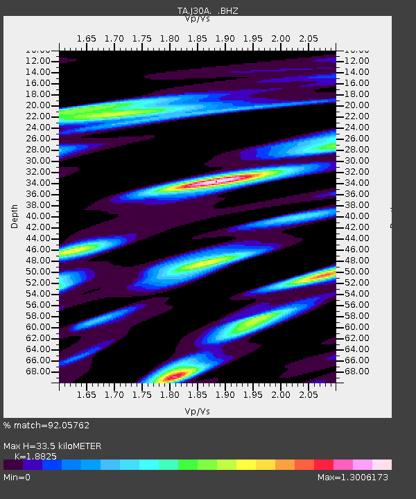
| Estimated Moho Depth: |
33.5 km |
| Estimated Crust Vp/Vs: |
1.88 |
| Assumed Crust Vp: |
6.53 km/s |
| Estimated Crust Vs: |
3.469 km/s |
| Estimated Crust Poisson's Ratio: |
0.30 |
|
| Radial Match: |
92.05762 % |
| Radial Bump: |
400 |
| Transverse Match: |
80.61544 % |
| Transverse Bump: |
400 |
| SOD ConfigId: |
319893 |
| Insert Time: |
2011-01-05 03:21:29.387 +0000 |
| GWidth: |
2.5 |
| Max Bumps: |
400 |
| Tol: |
0.001 |
|

Signal To Noise
| Channel | StoN | STA | LTA |
| TA:J30A: :BHZ:20100714T08:44:20.799998Z | 7.4780765 | 6.4051926E-7 | 8.565294E-8 |
| TA:J30A: :BHN:20100714T08:44:20.799998Z | 2.1478748 | 2.4100726E-7 | 1.1220731E-7 |
| TA:J30A: :BHE:20100714T08:44:20.799998Z | 1.4835382 | 1.5554977E-7 | 1.04850535E-7 |
| Arrivals |
| Ps | 4.6 SECOND |
| PpPs | 14 SECOND |
| PsPs/PpSs | 19 SECOND |


