You are here: Home > Network List > TA - USArray Transportable Network (new EarthScope stations) Stations List
> Station X32A Elmer, OK, USA > Earthquake Result Viewer
X32A Elmer, OK, USA - Earthquake Result Viewer
| Earthquake location: |
Near Coast Of Central Chile |
| Earthquake latitude/longitude: |
-38.1/-73.3 |
| Earthquake time(UTC): |
2010/07/14 (195) 08:32:21 GMT |
| Earthquake Depth: |
22 km |
| Earthquake Magnitude: |
5.9 MB, 6.5 MS, 6.6 MW, 6.5 MW |
| Earthquake Catalog/Contributor: |
WHDF/NEIC |
|
| Network: |
TA USArray Transportable Network (new EarthScope stations) |
| Station: |
X32A Elmer, OK, USA |
| Lat/Lon: |
34.42 N/99.29 W |
| Elevation: |
401 m |
|
| Distance: |
76.1 deg |
| Az: |
338.095 deg |
| Baz: |
159.133 deg |
| Ray Param: |
0.051231965 |
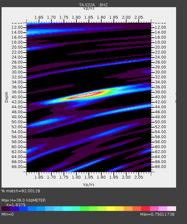
| Estimated Moho Depth: |
39.0 km |
| Estimated Crust Vp/Vs: |
1.84 |
| Assumed Crust Vp: |
6.315 km/s |
| Estimated Crust Vs: |
3.437 km/s |
| Estimated Crust Poisson's Ratio: |
0.29 |
|
| Radial Match: |
92.00126 % |
| Radial Bump: |
399 |
| Transverse Match: |
81.733116 % |
| Transverse Bump: |
400 |
| SOD ConfigId: |
319893 |
| Insert Time: |
2011-01-05 03:22:54.547 +0000 |
| GWidth: |
2.5 |
| Max Bumps: |
400 |
| Tol: |
0.001 |
|

Signal To Noise
| Channel | StoN | STA | LTA |
| TA:X32A: :BHZ:20100714T08:43:35.849985Z | 5.4370556 | 3.8830234E-7 | 7.1417766E-8 |
| TA:X32A: :BHN:20100714T08:43:35.849985Z | 2.9574766 | 2.4579086E-7 | 8.3108304E-8 |
| TA:X32A: :BHE:20100714T08:43:35.849985Z | 0.68264025 | 8.256001E-8 | 1.209422E-7 |
| Arrivals |
| Ps | 5.3 SECOND |
| PpPs | 17 SECOND |
| PsPs/PpSs | 22 SECOND |


