You are here: Home > Network List > TA - USArray Transportable Network (new EarthScope stations) Stations List
> Station W32A Sentinel, OK, USA > Earthquake Result Viewer
W32A Sentinel, OK, USA - Earthquake Result Viewer

| Earthquake location: |
Near Coast Of Central Chile |
| Earthquake latitude/longitude: |
-38.1/-73.3 |
| Earthquake time(UTC): |
2010/07/14 (195) 08:32:21 GMT |
| Earthquake Depth: |
22 km |
| Earthquake Magnitude: |
5.9 MB, 6.5 MS, 6.6 MW, 6.5 MW |
| Earthquake Catalog/Contributor: |
WHDF/NEIC |
|
| Network: |
TA USArray Transportable Network (new EarthScope stations) |
| Station: |
W32A Sentinel, OK, USA |
| Lat/Lon: |
35.12 N/99.25 W |
| Elevation: |
494 m |
|
| Distance: |
76.7 deg |
| Az: |
338.383 deg |
| Baz: |
159.223 deg |
| Ray Param: |
0.050799537 |
| Estimated Moho Depth: |
28.25 km |
| Estimated Crust Vp/Vs: |
2.10 |
| Assumed Crust Vp: |
6.315 km/s |
| Estimated Crust Vs: |
3.011 km/s |
| Estimated Crust Poisson's Ratio: |
0.35 |
|
| Radial Match: |
93.829155 % |
| Radial Bump: |
400 |
| Transverse Match: |
86.315765 % |
| Transverse Bump: |
400 |
| SOD ConfigId: |
319893 |
| Insert Time: |
2011-01-05 03:23:28.903 +0000 |
| GWidth: |
2.5 |
| Max Bumps: |
400 |
| Tol: |
0.001 |
|
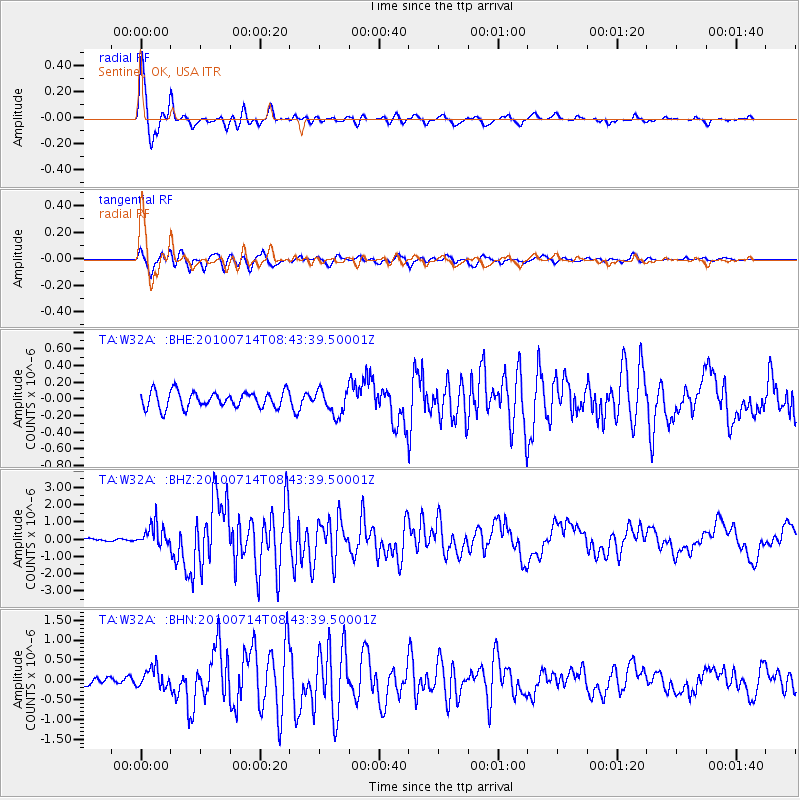
Signal To Noise
| Channel | StoN | STA | LTA |
| TA:W32A: :BHZ:20100714T08:43:39.50001Z | 8.023992 | 6.31082E-7 | 7.864938E-8 |
| TA:W32A: :BHN:20100714T08:43:39.50001Z | 1.7718658 | 2.3915655E-7 | 1.3497441E-7 |
| TA:W32A: :BHE:20100714T08:43:39.50001Z | 1.5483059 | 1.5101742E-7 | 9.7537196E-8 |
| Arrivals |
| Ps | 5.0 SECOND |
| PpPs | 14 SECOND |
| PsPs/PpSs | 19 SECOND |


