You are here: Home > Network List > TA - USArray Transportable Network (new EarthScope stations) Stations List
> Station Z33A Whitaker Ranch, Olney, TX, USA > Earthquake Result Viewer
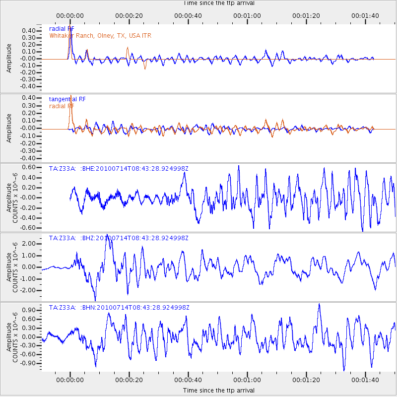
Z33A Whitaker Ranch, Olney, TX, USA - Earthquake Result Viewer

| Earthquake location: |
Near Coast Of Central Chile |
| Earthquake latitude/longitude: |
-38.1/-73.3 |
| Earthquake time(UTC): |
2010/07/14 (195) 08:32:21 GMT |
| Earthquake Depth: |
22 km |
| Earthquake Magnitude: |
5.9 MB, 6.5 MS, 6.6 MW, 6.5 MW |
| Earthquake Catalog/Contributor: |
WHDF/NEIC |
|
| Network: |
TA USArray Transportable Network (new EarthScope stations) |
| Station: |
Z33A Whitaker Ranch, Olney, TX, USA |
| Lat/Lon: |
33.29 N/98.76 W |
| Elevation: |
362 m |
|
| Distance: |
74.8 deg |
| Az: |
338.1 deg |
| Baz: |
159.423 deg |
| Ray Param: |
0.05204081 |
| Estimated Moho Depth: |
51.75 km |
| Estimated Crust Vp/Vs: |
1.99 |
| Assumed Crust Vp: |
6.426 km/s |
| Estimated Crust Vs: |
3.229 km/s |
| Estimated Crust Poisson's Ratio: |
0.33 |
|
| Radial Match: |
91.54839 % |
| Radial Bump: |
400 |
| Transverse Match: |
77.74357 % |
| Transverse Bump: |
400 |
| SOD ConfigId: |
319893 |
| Insert Time: |
2011-01-05 03:23:55.276 +0000 |
| GWidth: |
2.5 |
| Max Bumps: |
400 |
| Tol: |
0.001 |
|
Signal To Noise
| Channel | StoN | STA | LTA |
| TA:Z33A: :BHZ:20100714T08:43:28.924998Z | 4.1943793 | 4.4556072E-7 | 1.06228036E-7 |
| TA:Z33A: :BHN:20100714T08:43:28.924998Z | 2.0363078 | 1.8275387E-7 | 8.9747665E-8 |
| TA:Z33A: :BHE:20100714T08:43:28.924998Z | 0.6344483 | 6.78631E-8 | 1.0696395E-7 |
| Arrivals |
| Ps | 8.2 SECOND |
| PpPs | 23 SECOND |
| PsPs/PpSs | 32 SECOND |


