You are here: Home > Network List > TA - USArray Transportable Network (new EarthScope stations) Stations List
> Station 434A Burnet, TX, USA > Earthquake Result Viewer
434A Burnet, TX, USA - Earthquake Result Viewer
| Earthquake location: |
Near Coast Of Central Chile |
| Earthquake latitude/longitude: |
-38.1/-73.3 |
| Earthquake time(UTC): |
2010/07/14 (195) 08:32:21 GMT |
| Earthquake Depth: |
22 km |
| Earthquake Magnitude: |
5.9 MB, 6.5 MS, 6.6 MW, 6.5 MW |
| Earthquake Catalog/Contributor: |
WHDF/NEIC |
|
| Network: |
TA USArray Transportable Network (new EarthScope stations) |
| Station: |
434A Burnet, TX, USA |
| Lat/Lon: |
30.81 N/98.27 W |
| Elevation: |
462 m |
|
| Distance: |
72.4 deg |
| Az: |
337.61 deg |
| Baz: |
159.546 deg |
| Ray Param: |
0.053673003 |
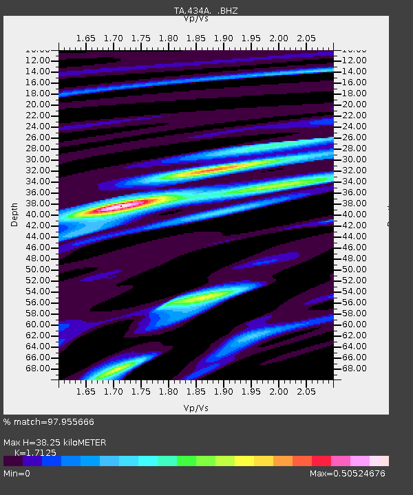
| Estimated Moho Depth: |
38.25 km |
| Estimated Crust Vp/Vs: |
1.71 |
| Assumed Crust Vp: |
6.498 km/s |
| Estimated Crust Vs: |
3.794 km/s |
| Estimated Crust Poisson's Ratio: |
0.24 |
|
| Radial Match: |
97.955666 % |
| Radial Bump: |
232 |
| Transverse Match: |
81.15835 % |
| Transverse Bump: |
400 |
| SOD ConfigId: |
319893 |
| Insert Time: |
2011-01-05 03:24:16.795 +0000 |
| GWidth: |
2.5 |
| Max Bumps: |
400 |
| Tol: |
0.001 |
|

Signal To Noise
| Channel | StoN | STA | LTA |
| TA:434A: :BHZ:20100714T08:43:14.524973Z | 6.8607297 | 4.8347675E-7 | 7.0470165E-8 |
| TA:434A: :BHN:20100714T08:43:14.524973Z | 3.6283178 | 1.9007689E-7 | 5.238706E-8 |
| TA:434A: :BHE:20100714T08:43:14.524973Z | 2.579168 | 1.02070906E-7 | 3.957513E-8 |
| Arrivals |
| Ps | 4.4 SECOND |
| PpPs | 15 SECOND |
| PsPs/PpSs | 20 SECOND |


