You are here: Home > Network List > TA - USArray Transportable Network (new EarthScope stations) Stations List
> Station 233A Rising Star, TX, USA > Earthquake Result Viewer
233A Rising Star, TX, USA - Earthquake Result Viewer
| Earthquake location: |
Near Coast Of Central Chile |
| Earthquake latitude/longitude: |
-38.1/-73.3 |
| Earthquake time(UTC): |
2010/07/14 (195) 08:32:21 GMT |
| Earthquake Depth: |
22 km |
| Earthquake Magnitude: |
5.9 MB, 6.5 MS, 6.6 MW, 6.5 MW |
| Earthquake Catalog/Contributor: |
WHDF/NEIC |
|
| Network: |
TA USArray Transportable Network (new EarthScope stations) |
| Station: |
233A Rising Star, TX, USA |
| Lat/Lon: |
32.02 N/98.90 W |
| Elevation: |
539 m |
|
| Distance: |
73.7 deg |
| Az: |
337.525 deg |
| Baz: |
159.194 deg |
| Ray Param: |
0.052809004 |
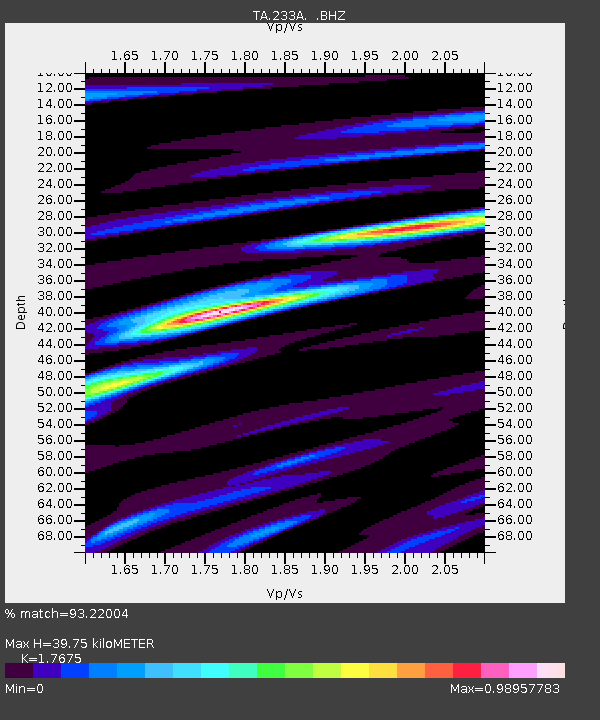
| Estimated Moho Depth: |
39.75 km |
| Estimated Crust Vp/Vs: |
1.77 |
| Assumed Crust Vp: |
6.426 km/s |
| Estimated Crust Vs: |
3.636 km/s |
| Estimated Crust Poisson's Ratio: |
0.26 |
|
| Radial Match: |
93.22004 % |
| Radial Bump: |
400 |
| Transverse Match: |
77.88568 % |
| Transverse Bump: |
400 |
| SOD ConfigId: |
319893 |
| Insert Time: |
2011-01-05 03:24:55.939 +0000 |
| GWidth: |
2.5 |
| Max Bumps: |
400 |
| Tol: |
0.001 |
|

Signal To Noise
| Channel | StoN | STA | LTA |
| TA:233A: :BHZ:20100714T08:43:22.274973Z | 7.2461324 | 5.131525E-7 | 7.081743E-8 |
| TA:233A: :BHN:20100714T08:43:22.274973Z | 2.2299929 | 1.9573494E-7 | 8.77738E-8 |
| TA:233A: :BHE:20100714T08:43:22.274973Z | 1.6898298 | 1.6205115E-7 | 9.589791E-8 |
| Arrivals |
| Ps | 4.9 SECOND |
| PpPs | 17 SECOND |
| PsPs/PpSs | 21 SECOND |


