You are here: Home > Network List > TA - USArray Transportable Network (new EarthScope stations) Stations List
> Station 734A La Parita Creek, Jourdanton, TX, USA > Earthquake Result Viewer
734A La Parita Creek, Jourdanton, TX, USA - Earthquake Result Viewer
| Earthquake location: |
Near Coast Of Central Chile |
| Earthquake latitude/longitude: |
-38.1/-73.3 |
| Earthquake time(UTC): |
2010/07/14 (195) 08:32:21 GMT |
| Earthquake Depth: |
22 km |
| Earthquake Magnitude: |
5.9 MB, 6.5 MS, 6.6 MW, 6.5 MW |
| Earthquake Catalog/Contributor: |
WHDF/NEIC |
|
| Network: |
TA USArray Transportable Network (new EarthScope stations) |
| Station: |
734A La Parita Creek, Jourdanton, TX, USA |
| Lat/Lon: |
28.85 N/98.56 W |
| Elevation: |
121 m |
|
| Distance: |
70.6 deg |
| Az: |
336.633 deg |
| Baz: |
159.094 deg |
| Ray Param: |
0.054826617 |
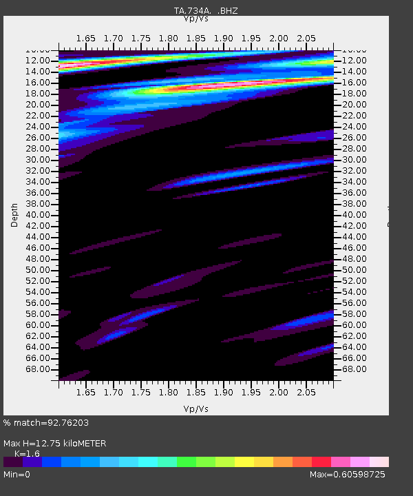
| Estimated Moho Depth: |
12.75 km |
| Estimated Crust Vp/Vs: |
1.60 |
| Assumed Crust Vp: |
6.347 km/s |
| Estimated Crust Vs: |
3.967 km/s |
| Estimated Crust Poisson's Ratio: |
0.18 |
|
| Radial Match: |
92.76203 % |
| Radial Bump: |
400 |
| Transverse Match: |
75.83428 % |
| Transverse Bump: |
400 |
| SOD ConfigId: |
319893 |
| Insert Time: |
2011-01-05 03:25:06.171 +0000 |
| GWidth: |
2.5 |
| Max Bumps: |
400 |
| Tol: |
0.001 |
|

Signal To Noise
| Channel | StoN | STA | LTA |
| TA:734A: :BHZ:20100714T08:43:04.049998Z | 2.7753382 | 5.216827E-7 | 1.8797085E-7 |
| TA:734A: :BHN:20100714T08:43:04.049998Z | 0.90548295 | 2.0375637E-7 | 2.2502509E-7 |
| TA:734A: :BHE:20100714T08:43:04.049998Z | 0.91325146 | 1.5453197E-7 | 1.6921076E-7 |
| Arrivals |
| Ps | 1.3 SECOND |
| PpPs | 5.0 SECOND |
| PsPs/PpSs | 6.3 SECOND |


