You are here: Home > Network List > TA - USArray Transportable Network (new EarthScope stations) Stations List
> Station 634A China Grove, San Antonio TX, USA > Earthquake Result Viewer
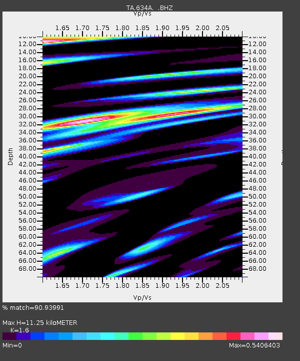
634A China Grove, San Antonio TX, USA - Earthquake Result Viewer
| Earthquake location: |
Near Coast Of Central Chile |
| Earthquake latitude/longitude: |
-38.1/-73.3 |
| Earthquake time(UTC): |
2010/07/14 (195) 08:32:21 GMT |
| Earthquake Depth: |
22 km |
| Earthquake Magnitude: |
5.9 MB, 6.5 MS, 6.6 MW, 6.5 MW |
| Earthquake Catalog/Contributor: |
WHDF/NEIC |
|
| Network: |
TA USArray Transportable Network (new EarthScope stations) |
| Station: |
634A China Grove, San Antonio TX, USA |
| Lat/Lon: |
29.38 N/98.35 W |
| Elevation: |
188 m |
|
| Distance: |
71.1 deg |
| Az: |
337.012 deg |
| Baz: |
159.317 deg |
| Ray Param: |
0.054539237 |
| Estimated Moho Depth: |
11.25 km |
| Estimated Crust Vp/Vs: |
1.60 |
| Assumed Crust Vp: |
6.347 km/s |
| Estimated Crust Vs: |
3.967 km/s |
| Estimated Crust Poisson's Ratio: |
0.18 |
|
| Radial Match: |
90.93991 % |
| Radial Bump: |
400 |
| Transverse Match: |
80.4436 % |
| Transverse Bump: |
400 |
| SOD ConfigId: |
319893 |
| Insert Time: |
2011-01-05 03:25:19.446 +0000 |
| GWidth: |
2.5 |
| Max Bumps: |
400 |
| Tol: |
0.001 |
|

Signal To Noise
| Channel | StoN | STA | LTA |
| TA:634A: :BHZ:20100714T08:43:06.649973Z | 3.179396 | 4.4895506E-7 | 1.4120766E-7 |
| TA:634A: :BHN:20100714T08:43:06.649973Z | 1.7900795 | 1.6875197E-7 | 9.427066E-8 |
| TA:634A: :BHE:20100714T08:43:06.649973Z | 1.3450545 | 2.477062E-7 | 1.8416071E-7 |
| Arrivals |
| Ps | 1.1 SECOND |
| PpPs | 4.4 SECOND |
| PsPs/PpSs | 5.5 SECOND |


