You are here: Home > Network List > TA - USArray Transportable Network (new EarthScope stations) Stations List
> Station 535A Dale, TX, USA > Earthquake Result Viewer
535A Dale, TX, USA - Earthquake Result Viewer
| Earthquake location: |
Near Coast Of Central Chile |
| Earthquake latitude/longitude: |
-38.1/-73.3 |
| Earthquake time(UTC): |
2010/07/14 (195) 08:32:21 GMT |
| Earthquake Depth: |
22 km |
| Earthquake Magnitude: |
5.9 MB, 6.5 MS, 6.6 MW, 6.5 MW |
| Earthquake Catalog/Contributor: |
WHDF/NEIC |
|
| Network: |
TA USArray Transportable Network (new EarthScope stations) |
| Station: |
535A Dale, TX, USA |
| Lat/Lon: |
30.03 N/97.57 W |
| Elevation: |
170 m |
|
| Distance: |
71.4 deg |
| Az: |
337.921 deg |
| Baz: |
159.994 deg |
| Ray Param: |
0.05430289 |
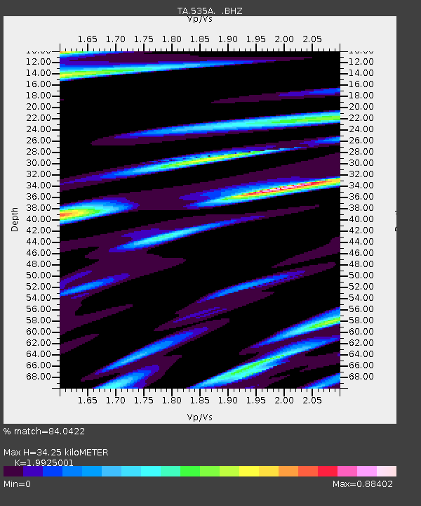
| Estimated Moho Depth: |
34.25 km |
| Estimated Crust Vp/Vs: |
1.99 |
| Assumed Crust Vp: |
6.347 km/s |
| Estimated Crust Vs: |
3.185 km/s |
| Estimated Crust Poisson's Ratio: |
0.33 |
|
| Radial Match: |
84.0422 % |
| Radial Bump: |
400 |
| Transverse Match: |
76.56392 % |
| Transverse Bump: |
400 |
| SOD ConfigId: |
319893 |
| Insert Time: |
2011-01-05 03:25:31.596 +0000 |
| GWidth: |
2.5 |
| Max Bumps: |
400 |
| Tol: |
0.001 |
|
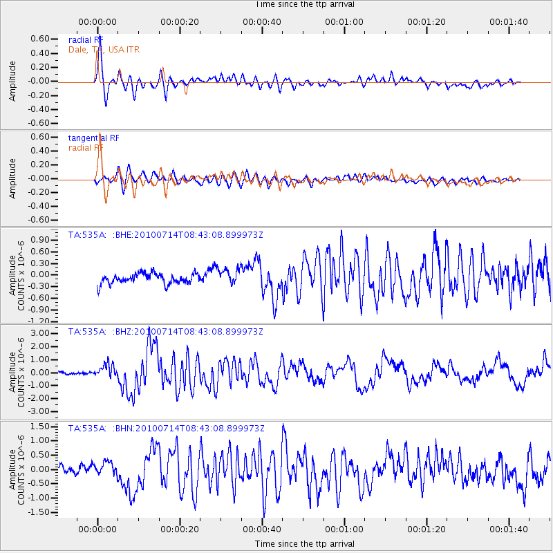
Signal To Noise
| Channel | StoN | STA | LTA |
| TA:535A: :BHZ:20100714T08:43:08.899973Z | 5.2179832 | 5.068833E-7 | 9.71416E-8 |
| TA:535A: :BHN:20100714T08:43:08.899973Z | 0.75030303 | 2.0382535E-7 | 2.7165737E-7 |
| TA:535A: :BHE:20100714T08:43:08.899973Z | 1.6123904 | 2.0991227E-7 | 1.30187E-7 |
| Arrivals |
| Ps | 5.5 SECOND |
| PpPs | 16 SECOND |
| PsPs/PpSs | 21 SECOND |


