You are here: Home > Network List > TA - USArray Transportable Network (new EarthScope stations) Stations List
> Station 336A Riesel, TX, USA > Earthquake Result Viewer
336A Riesel, TX, USA - Earthquake Result Viewer

| Earthquake location: |
Near Coast Of Central Chile |
| Earthquake latitude/longitude: |
-38.1/-73.3 |
| Earthquake time(UTC): |
2010/07/14 (195) 08:32:21 GMT |
| Earthquake Depth: |
22 km |
| Earthquake Magnitude: |
5.9 MB, 6.5 MS, 6.6 MW, 6.5 MW |
| Earthquake Catalog/Contributor: |
WHDF/NEIC |
|
| Network: |
TA USArray Transportable Network (new EarthScope stations) |
| Station: |
336A Riesel, TX, USA |
| Lat/Lon: |
31.39 N/96.84 W |
| Elevation: |
140 m |
|
| Distance: |
72.5 deg |
| Az: |
339.019 deg |
| Baz: |
160.704 deg |
| Ray Param: |
0.053593297 |
| Estimated Moho Depth: |
30.5 km |
| Estimated Crust Vp/Vs: |
1.74 |
| Assumed Crust Vp: |
6.347 km/s |
| Estimated Crust Vs: |
3.648 km/s |
| Estimated Crust Poisson's Ratio: |
0.25 |
|
| Radial Match: |
97.45126 % |
| Radial Bump: |
326 |
| Transverse Match: |
90.114914 % |
| Transverse Bump: |
400 |
| SOD ConfigId: |
319893 |
| Insert Time: |
2011-01-05 03:26:39.351 +0000 |
| GWidth: |
2.5 |
| Max Bumps: |
400 |
| Tol: |
0.001 |
|
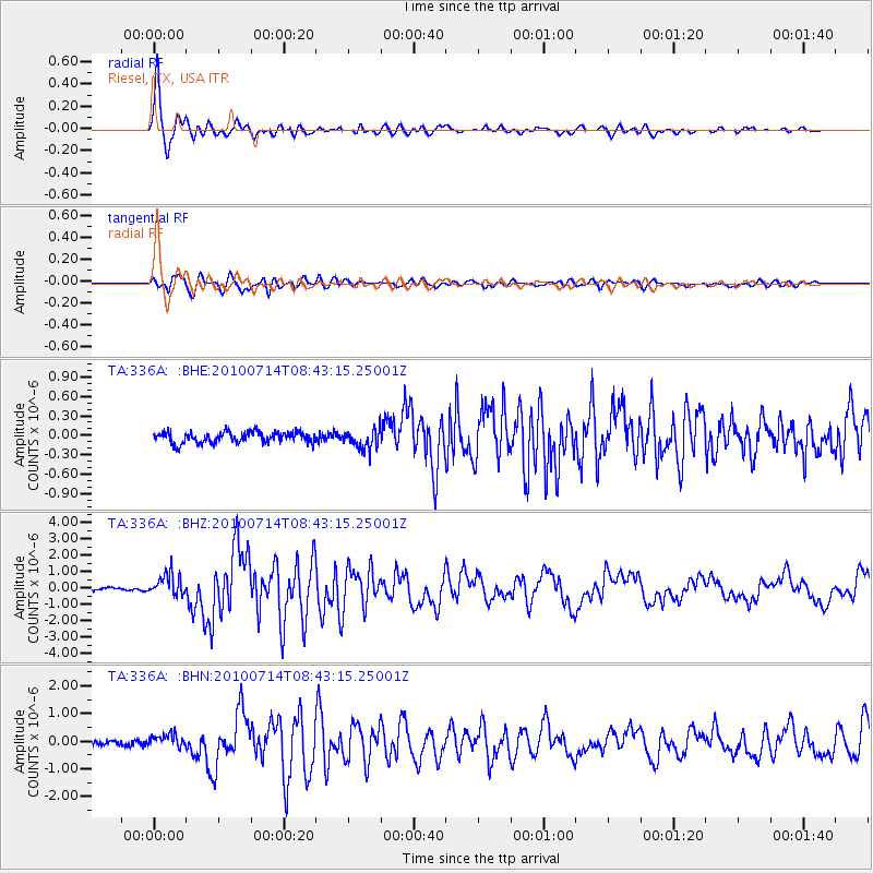
Signal To Noise
| Channel | StoN | STA | LTA |
| TA:336A: :BHZ:20100714T08:43:15.25001Z | 9.585521 | 6.704777E-7 | 6.994692E-8 |
| TA:336A: :BHN:20100714T08:43:15.25001Z | 3.055638 | 2.3864223E-7 | 7.8098985E-8 |
| TA:336A: :BHE:20100714T08:43:15.25001Z | 1.8333894 | 1.5314764E-7 | 8.353252E-8 |
| Arrivals |
| Ps | 3.7 SECOND |
| PpPs | 13 SECOND |
| PsPs/PpSs | 16 SECOND |


