You are here: Home > Network List > TA - USArray Transportable Network (new EarthScope stations) Stations List
> Station 340A Bronson, TX, USA > Earthquake Result Viewer
340A Bronson, TX, USA - Earthquake Result Viewer
| Earthquake location: |
Near Coast Of Central Chile |
| Earthquake latitude/longitude: |
-38.1/-73.3 |
| Earthquake time(UTC): |
2010/07/14 (195) 08:32:21 GMT |
| Earthquake Depth: |
22 km |
| Earthquake Magnitude: |
5.9 MB, 6.5 MS, 6.6 MW, 6.5 MW |
| Earthquake Catalog/Contributor: |
WHDF/NEIC |
|
| Network: |
TA USArray Transportable Network (new EarthScope stations) |
| Station: |
340A Bronson, TX, USA |
| Lat/Lon: |
31.42 N/93.89 W |
| Elevation: |
57 m |
|
| Distance: |
71.7 deg |
| Az: |
341.552 deg |
| Baz: |
163.013 deg |
| Ray Param: |
0.054098684 |
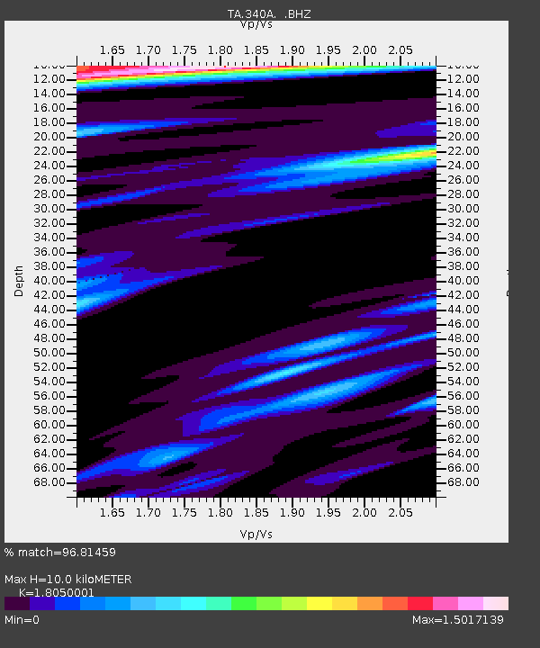
| Estimated Moho Depth: |
10.0 km |
| Estimated Crust Vp/Vs: |
1.81 |
| Assumed Crust Vp: |
6.065 km/s |
| Estimated Crust Vs: |
3.36 km/s |
| Estimated Crust Poisson's Ratio: |
0.28 |
|
| Radial Match: |
96.81459 % |
| Radial Bump: |
375 |
| Transverse Match: |
77.92873 % |
| Transverse Bump: |
400 |
| SOD ConfigId: |
319893 |
| Insert Time: |
2011-01-05 03:26:55.515 +0000 |
| GWidth: |
2.5 |
| Max Bumps: |
400 |
| Tol: |
0.001 |
|

Signal To Noise
| Channel | StoN | STA | LTA |
| TA:340A: :BHZ:20100714T08:43:10.724985Z | 6.796826 | 7.416692E-7 | 1.0911994E-7 |
| TA:340A: :BHN:20100714T08:43:10.724985Z | 1.5101144 | 2.7158478E-7 | 1.7984385E-7 |
| TA:340A: :BHE:20100714T08:43:10.724985Z | 0.88788104 | 1.3241079E-7 | 1.4913122E-7 |
| Arrivals |
| Ps | 1.4 SECOND |
| PpPs | 4.5 SECOND |
| PsPs/PpSs | 5.9 SECOND |


