You are here: Home > Network List > TA - USArray Transportable Network (new EarthScope stations) Stations List
> Station Q37A Longview Farm, Lee's Summit, MO, USA > Earthquake Result Viewer
Q37A Longview Farm, Lee's Summit, MO, USA - Earthquake Result Viewer

| Earthquake location: |
Near Coast Of Central Chile |
| Earthquake latitude/longitude: |
-38.1/-73.3 |
| Earthquake time(UTC): |
2010/07/14 (195) 08:32:21 GMT |
| Earthquake Depth: |
22 km |
| Earthquake Magnitude: |
5.9 MB, 6.5 MS, 6.6 MW, 6.5 MW |
| Earthquake Catalog/Contributor: |
WHDF/NEIC |
|
| Network: |
TA USArray Transportable Network (new EarthScope stations) |
| Station: |
Q37A Longview Farm, Lee's Summit, MO, USA |
| Lat/Lon: |
38.88 N/94.45 W |
| Elevation: |
297 m |
|
| Distance: |
79.0 deg |
| Az: |
343.333 deg |
| Baz: |
163.141 deg |
| Ray Param: |
0.049238402 |
| Estimated Moho Depth: |
40.25 km |
| Estimated Crust Vp/Vs: |
1.89 |
| Assumed Crust Vp: |
6.498 km/s |
| Estimated Crust Vs: |
3.438 km/s |
| Estimated Crust Poisson's Ratio: |
0.31 |
|
| Radial Match: |
92.73769 % |
| Radial Bump: |
400 |
| Transverse Match: |
68.931816 % |
| Transverse Bump: |
400 |
| SOD ConfigId: |
319893 |
| Insert Time: |
2011-01-05 03:27:41.344 +0000 |
| GWidth: |
2.5 |
| Max Bumps: |
400 |
| Tol: |
0.001 |
|
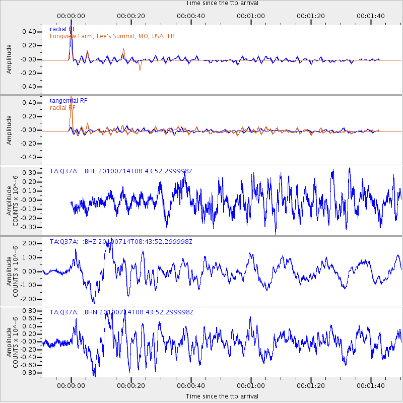
Signal To Noise
| Channel | StoN | STA | LTA |
| TA:Q37A: :BHZ:20100714T08:43:52.299998Z | 8.185107 | 6.6753665E-7 | 8.155503E-8 |
| TA:Q37A: :BHN:20100714T08:43:52.299998Z | 3.016134 | 2.1652518E-7 | 7.178898E-8 |
| TA:Q37A: :BHE:20100714T08:43:52.299998Z | 2.2943 | 1.4025412E-7 | 6.1131544E-8 |
| Arrivals |
| Ps | 5.7 SECOND |
| PpPs | 17 SECOND |
| PsPs/PpSs | 23 SECOND |


