You are here: Home > Network List > TA - USArray Transportable Network (new EarthScope stations) Stations List
> Station W38A Poteau, OK, USA > Earthquake Result Viewer
W38A Poteau, OK, USA - Earthquake Result Viewer

| Earthquake location: |
Near Coast Of Central Chile |
| Earthquake latitude/longitude: |
-38.1/-73.3 |
| Earthquake time(UTC): |
2010/07/14 (195) 08:32:21 GMT |
| Earthquake Depth: |
22 km |
| Earthquake Magnitude: |
5.9 MB, 6.5 MS, 6.6 MW, 6.5 MW |
| Earthquake Catalog/Contributor: |
WHDF/NEIC |
|
| Network: |
TA USArray Transportable Network (new EarthScope stations) |
| Station: |
W38A Poteau, OK, USA |
| Lat/Lon: |
35.07 N/94.52 W |
| Elevation: |
169 m |
|
| Distance: |
75.4 deg |
| Az: |
342.142 deg |
| Baz: |
162.837 deg |
| Ray Param: |
0.051682893 |
| Estimated Moho Depth: |
19.0 km |
| Estimated Crust Vp/Vs: |
1.79 |
| Assumed Crust Vp: |
6.498 km/s |
| Estimated Crust Vs: |
3.625 km/s |
| Estimated Crust Poisson's Ratio: |
0.27 |
|
| Radial Match: |
89.90346 % |
| Radial Bump: |
400 |
| Transverse Match: |
78.903656 % |
| Transverse Bump: |
400 |
| SOD ConfigId: |
319893 |
| Insert Time: |
2011-01-05 03:28:31.796 +0000 |
| GWidth: |
2.5 |
| Max Bumps: |
400 |
| Tol: |
0.001 |
|
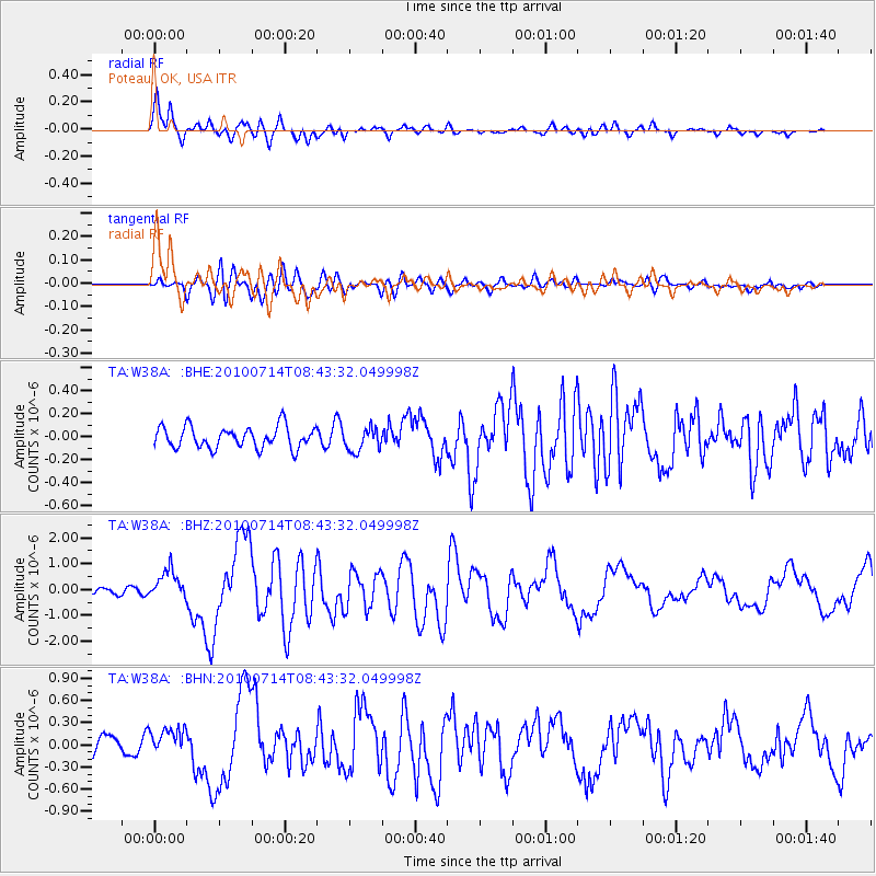
Signal To Noise
| Channel | StoN | STA | LTA |
| TA:W38A: :BHZ:20100714T08:43:32.049998Z | 5.6796813 | 5.7477894E-7 | 1.0119915E-7 |
| TA:W38A: :BHN:20100714T08:43:32.049998Z | 1.7751848 | 1.770616E-7 | 9.974263E-8 |
| TA:W38A: :BHE:20100714T08:43:32.049998Z | 1.0656648 | 9.8815505E-8 | 9.272663E-8 |
| Arrivals |
| Ps | 2.4 SECOND |
| PpPs | 7.9 SECOND |
| PsPs/PpSs | 10 SECOND |


