You are here: Home > Network List > TA - USArray Transportable Network (new EarthScope stations) Stations List
> Station Z38A Mt. Pleasant, TX, USA > Earthquake Result Viewer
Z38A Mt. Pleasant, TX, USA - Earthquake Result Viewer
| Earthquake location: |
Near Coast Of Central Chile |
| Earthquake latitude/longitude: |
-38.1/-73.3 |
| Earthquake time(UTC): |
2010/07/14 (195) 08:32:21 GMT |
| Earthquake Depth: |
22 km |
| Earthquake Magnitude: |
5.9 MB, 6.5 MS, 6.6 MW, 6.5 MW |
| Earthquake Catalog/Contributor: |
WHDF/NEIC |
|
| Network: |
TA USArray Transportable Network (new EarthScope stations) |
| Station: |
Z38A Mt. Pleasant, TX, USA |
| Lat/Lon: |
33.25 N/94.99 W |
| Elevation: |
116 m |
|
| Distance: |
73.8 deg |
| Az: |
341.195 deg |
| Baz: |
162.324 deg |
| Ray Param: |
0.052761327 |
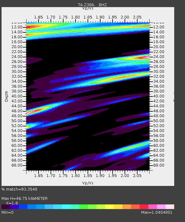
| Estimated Moho Depth: |
46.75 km |
| Estimated Crust Vp/Vs: |
1.60 |
| Assumed Crust Vp: |
6.245 km/s |
| Estimated Crust Vs: |
3.903 km/s |
| Estimated Crust Poisson's Ratio: |
0.18 |
|
| Radial Match: |
93.3548 % |
| Radial Bump: |
400 |
| Transverse Match: |
71.40874 % |
| Transverse Bump: |
400 |
| SOD ConfigId: |
319893 |
| Insert Time: |
2011-01-05 03:28:43.828 +0000 |
| GWidth: |
2.5 |
| Max Bumps: |
400 |
| Tol: |
0.001 |
|

Signal To Noise
| Channel | StoN | STA | LTA |
| TA:Z38A: :BHZ:20100714T08:43:22.700022Z | 5.090844 | 6.2761455E-7 | 1.23283E-7 |
| TA:Z38A: :BHN:20100714T08:43:22.700022Z | 1.7141255 | 2.3143946E-7 | 1.3501896E-7 |
| TA:Z38A: :BHE:20100714T08:43:22.700022Z | 0.79857576 | 1.825177E-7 | 2.2855403E-7 |
| Arrivals |
| Ps | 4.7 SECOND |
| PpPs | 19 SECOND |
| PsPs/PpSs | 23 SECOND |


