You are here: Home > Network List > TA - USArray Transportable Network (new EarthScope stations) Stations List
> Station Y36A Durant, OK, USA > Earthquake Result Viewer
Y36A Durant, OK, USA - Earthquake Result Viewer
| Earthquake location: |
Near Coast Of Central Chile |
| Earthquake latitude/longitude: |
-38.1/-73.3 |
| Earthquake time(UTC): |
2010/07/14 (195) 08:32:21 GMT |
| Earthquake Depth: |
22 km |
| Earthquake Magnitude: |
5.9 MB, 6.5 MS, 6.6 MW, 6.5 MW |
| Earthquake Catalog/Contributor: |
WHDF/NEIC |
|
| Network: |
TA USArray Transportable Network (new EarthScope stations) |
| Station: |
Y36A Durant, OK, USA |
| Lat/Lon: |
33.90 N/96.28 W |
| Elevation: |
186 m |
|
| Distance: |
74.7 deg |
| Az: |
340.333 deg |
| Baz: |
161.375 deg |
| Ray Param: |
0.052120432 |
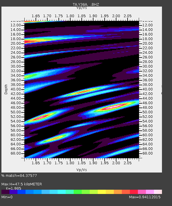
| Estimated Moho Depth: |
47.5 km |
| Estimated Crust Vp/Vs: |
1.99 |
| Assumed Crust Vp: |
6.38 km/s |
| Estimated Crust Vs: |
3.214 km/s |
| Estimated Crust Poisson's Ratio: |
0.33 |
|
| Radial Match: |
84.37577 % |
| Radial Bump: |
400 |
| Transverse Match: |
70.995445 % |
| Transverse Bump: |
400 |
| SOD ConfigId: |
319893 |
| Insert Time: |
2011-01-05 03:28:59.746 +0000 |
| GWidth: |
2.5 |
| Max Bumps: |
400 |
| Tol: |
0.001 |
|

Signal To Noise
| Channel | StoN | STA | LTA |
| TA:Y36A: :BHZ:20100714T08:43:28.224985Z | 4.097335 | 5.637422E-7 | 1.3758755E-7 |
| TA:Y36A: :BHN:20100714T08:43:28.224985Z | 1.7743162 | 2.1924237E-7 | 1.2356442E-7 |
| TA:Y36A: :BHE:20100714T08:43:28.224985Z | 1.3439722 | 1.4131808E-7 | 1.0514955E-7 |
| Arrivals |
| Ps | 7.5 SECOND |
| PpPs | 22 SECOND |
| PsPs/PpSs | 29 SECOND |


