You are here: Home > Network List > TA - USArray Transportable Network (new EarthScope stations) Stations List
> Station O35A Humboldt, NE, USA > Earthquake Result Viewer
O35A Humboldt, NE, USA - Earthquake Result Viewer
| Earthquake location: |
Near Coast Of Central Chile |
| Earthquake latitude/longitude: |
-38.1/-73.3 |
| Earthquake time(UTC): |
2010/07/14 (195) 08:32:21 GMT |
| Earthquake Depth: |
22 km |
| Earthquake Magnitude: |
5.9 MB, 6.5 MS, 6.6 MW, 6.5 MW |
| Earthquake Catalog/Contributor: |
WHDF/NEIC |
|
| Network: |
TA USArray Transportable Network (new EarthScope stations) |
| Station: |
O35A Humboldt, NE, USA |
| Lat/Lon: |
40.27 N/95.91 W |
| Elevation: |
342 m |
|
| Distance: |
80.7 deg |
| Az: |
342.662 deg |
| Baz: |
162.098 deg |
| Ray Param: |
0.048102852 |
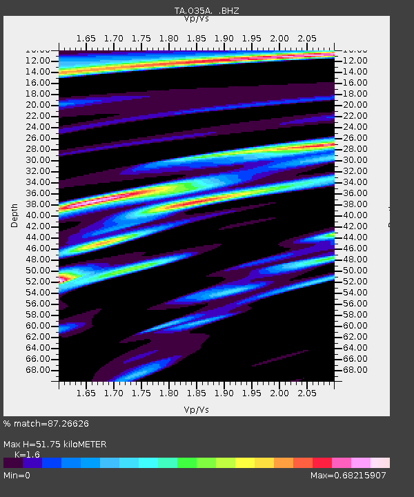
| Estimated Moho Depth: |
51.75 km |
| Estimated Crust Vp/Vs: |
1.60 |
| Assumed Crust Vp: |
6.498 km/s |
| Estimated Crust Vs: |
4.061 km/s |
| Estimated Crust Poisson's Ratio: |
0.18 |
|
| Radial Match: |
87.26626 % |
| Radial Bump: |
400 |
| Transverse Match: |
76.12378 % |
| Transverse Bump: |
400 |
| SOD ConfigId: |
319893 |
| Insert Time: |
2011-01-05 03:30:25.789 +0000 |
| GWidth: |
2.5 |
| Max Bumps: |
400 |
| Tol: |
0.001 |
|

Signal To Noise
| Channel | StoN | STA | LTA |
| TA:O35A: :BHZ:20100714T08:44:01.25001Z | 6.986983 | 5.3781116E-7 | 7.697331E-8 |
| TA:O35A: :BHN:20100714T08:44:01.25001Z | 1.5312923 | 2.4486482E-7 | 1.599073E-7 |
| TA:O35A: :BHE:20100714T08:44:01.25001Z | 1.200634 | 1.8360261E-7 | 1.5292139E-7 |
| Arrivals |
| Ps | 4.9 SECOND |
| PpPs | 20 SECOND |
| PsPs/PpSs | 25 SECOND |


