You are here: Home > Network List > TA - USArray Transportable Network (new EarthScope stations) Stations List
> Station P35A Duane Minner, Soldier, KS, USA > Earthquake Result Viewer
P35A Duane Minner, Soldier, KS, USA - Earthquake Result Viewer

| Earthquake location: |
Near Coast Of Central Chile |
| Earthquake latitude/longitude: |
-38.1/-73.3 |
| Earthquake time(UTC): |
2010/07/14 (195) 08:32:21 GMT |
| Earthquake Depth: |
22 km |
| Earthquake Magnitude: |
5.9 MB, 6.5 MS, 6.6 MW, 6.5 MW |
| Earthquake Catalog/Contributor: |
WHDF/NEIC |
|
| Network: |
TA USArray Transportable Network (new EarthScope stations) |
| Station: |
P35A Duane Minner, Soldier, KS, USA |
| Lat/Lon: |
39.53 N/96.02 W |
| Elevation: |
418 m |
|
| Distance: |
80.0 deg |
| Az: |
342.351 deg |
| Baz: |
161.976 deg |
| Ray Param: |
0.04856303 |
| Estimated Moho Depth: |
44.0 km |
| Estimated Crust Vp/Vs: |
1.80 |
| Assumed Crust Vp: |
6.483 km/s |
| Estimated Crust Vs: |
3.596 km/s |
| Estimated Crust Poisson's Ratio: |
0.28 |
|
| Radial Match: |
91.12047 % |
| Radial Bump: |
400 |
| Transverse Match: |
75.61286 % |
| Transverse Bump: |
400 |
| SOD ConfigId: |
319893 |
| Insert Time: |
2011-01-05 03:30:32.183 +0000 |
| GWidth: |
2.5 |
| Max Bumps: |
400 |
| Tol: |
0.001 |
|
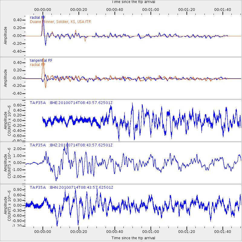
Signal To Noise
| Channel | StoN | STA | LTA |
| TA:P35A: :BHZ:20100714T08:43:57.62501Z | 7.256775 | 6.829241E-7 | 9.4108486E-8 |
| TA:P35A: :BHN:20100714T08:43:57.62501Z | 2.0028234 | 2.2394978E-7 | 1.11817045E-7 |
| TA:P35A: :BHE:20100714T08:43:57.62501Z | 1.481461 | 1.4119075E-7 | 9.5305076E-8 |
| Arrivals |
| Ps | 5.6 SECOND |
| PpPs | 18 SECOND |
| PsPs/PpSs | 24 SECOND |


