You are here: Home > Network List > G - GEOSCOPE Stations List
> Station INU Inuyama, Japan > Earthquake Result Viewer
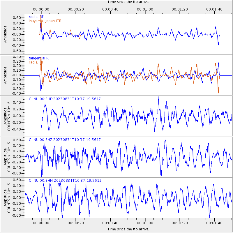
INU Inuyama, Japan - Earthquake Result Viewer
*The percent match for this event was below the threshold and hence no stack was calculated.
| Earthquake location: |
Timor Region |
| Earthquake latitude/longitude: |
-9.5/123.9 |
| Earthquake time(UTC): |
2023/08/31 (243) 10:29:29 GMT |
| Earthquake Depth: |
55 km |
| Earthquake Magnitude: |
5.4 mww |
| Earthquake Catalog/Contributor: |
NEIC PDE/us |
|
| Network: |
G GEOSCOPE |
| Station: |
INU Inuyama, Japan |
| Lat/Lon: |
35.35 N/137.03 E |
| Elevation: |
132 m |
|
| Distance: |
46.3 deg |
| Az: |
14.918 deg |
| Baz: |
198.097 deg |
| Ray Param: |
$rayparam |
*The percent match for this event was below the threshold and hence was not used in the summary stack. |
|
| Radial Match: |
58.264584 % |
| Radial Bump: |
400 |
| Transverse Match: |
39.062176 % |
| Transverse Bump: |
400 |
| SOD ConfigId: |
31937991 |
| Insert Time: |
2023-09-14 10:35:27.711 +0000 |
| GWidth: |
2.5 |
| Max Bumps: |
400 |
| Tol: |
0.001 |
|
Signal To Noise
| Channel | StoN | STA | LTA |
| G:INU:00:BHZ:20230831T10:37:19.561Z | 2.3027902 | 3.2054896E-7 | 1.3920025E-7 |
| G:INU:00:BHN:20230831T10:37:19.561Z | 1.1626364 | 2.7400324E-7 | 2.3567407E-7 |
| G:INU:00:BHE:20230831T10:37:19.561Z | 1.2176172 | 2.1430404E-7 | 1.7600281E-7 |
| Arrivals |
| Ps | |
| PpPs | |
| PsPs/PpSs | |


