You are here: Home > Network List > C0 - Colorado Geological Survey Seismic Network Stations List
> Station HAYD Hayden Colorado > Earthquake Result Viewer
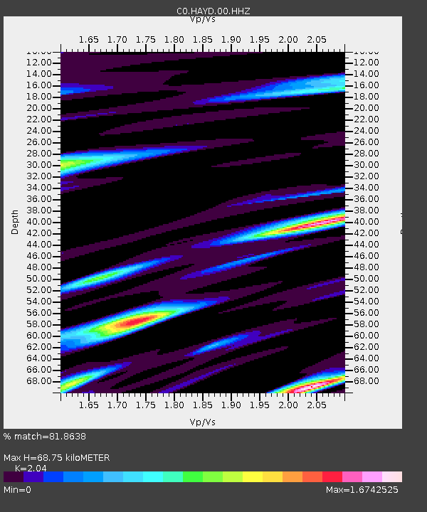
HAYD Hayden Colorado - Earthquake Result Viewer
| Earthquake location: |
Kuril Islands |
| Earthquake latitude/longitude: |
50.7/156.3 |
| Earthquake time(UTC): |
2023/09/01 (244) 20:49:54 GMT |
| Earthquake Depth: |
141 km |
| Earthquake Magnitude: |
6.1 Mww |
| Earthquake Catalog/Contributor: |
NEIC PDE/us |
|
| Network: |
C0 Colorado Geological Survey Seismic Network |
| Station: |
HAYD Hayden Colorado |
| Lat/Lon: |
40.53 N/107.27 W |
| Elevation: |
2202 m |
|
| Distance: |
63.6 deg |
| Az: |
57.78 deg |
| Baz: |
315.108 deg |
| Ray Param: |
0.0590935 |
| Estimated Moho Depth: |
68.75 km |
| Estimated Crust Vp/Vs: |
2.04 |
| Assumed Crust Vp: |
6.159 km/s |
| Estimated Crust Vs: |
3.019 km/s |
| Estimated Crust Poisson's Ratio: |
0.34 |
|
| Radial Match: |
81.8638 % |
| Radial Bump: |
400 |
| Transverse Match: |
77.843895 % |
| Transverse Bump: |
360 |
| SOD ConfigId: |
31937991 |
| Insert Time: |
2023-09-15 20:57:08.367 +0000 |
| GWidth: |
2.5 |
| Max Bumps: |
400 |
| Tol: |
0.001 |
|

Signal To Noise
| Channel | StoN | STA | LTA |
| C0:HAYD:00:HHZ:20230901T20:59:39.60503Z | 5.3066444 | 5.7649964E-7 | 1.08637316E-7 |
| C0:HAYD:00:HHN:20230901T20:59:39.60503Z | 1.4777079 | 2.1834275E-7 | 1.4775772E-7 |
| C0:HAYD:00:HHE:20230901T20:59:39.60503Z | 0.7309633 | 1.11579446E-7 | 1.5264712E-7 |
| Arrivals |
| Ps | 12 SECOND |
| PpPs | 33 SECOND |
| PsPs/PpSs | 45 SECOND |


