You are here: Home > Network List > CC - Cascade Chain Volcano Monitoring Stations List
> Station MILD Mildred Point > Earthquake Result Viewer
MILD Mildred Point - Earthquake Result Viewer
| Earthquake location: |
Kuril Islands |
| Earthquake latitude/longitude: |
50.7/156.3 |
| Earthquake time(UTC): |
2023/09/01 (244) 20:49:54 GMT |
| Earthquake Depth: |
141 km |
| Earthquake Magnitude: |
6.1 Mww |
| Earthquake Catalog/Contributor: |
NEIC PDE/us |
|
| Network: |
CC Cascade Chain Volcano Monitoring |
| Station: |
MILD Mildred Point |
| Lat/Lon: |
46.81 N/121.78 W |
| Elevation: |
2016 m |
|
| Distance: |
51.5 deg |
| Az: |
60.323 deg |
| Baz: |
306.454 deg |
| Ray Param: |
0.06688142 |
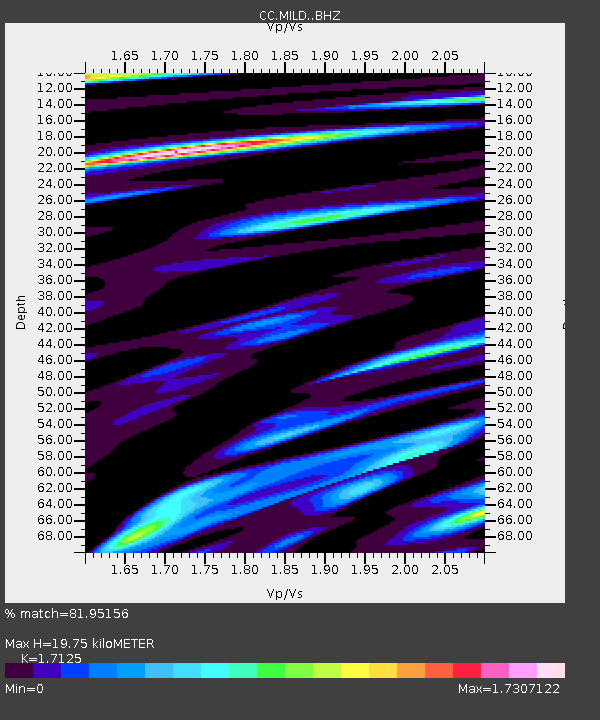
| Estimated Moho Depth: |
19.75 km |
| Estimated Crust Vp/Vs: |
1.71 |
| Assumed Crust Vp: |
6.597 km/s |
| Estimated Crust Vs: |
3.853 km/s |
| Estimated Crust Poisson's Ratio: |
0.24 |
|
| Radial Match: |
81.95156 % |
| Radial Bump: |
400 |
| Transverse Match: |
73.494514 % |
| Transverse Bump: |
400 |
| SOD ConfigId: |
31937991 |
| Insert Time: |
2023-09-15 20:58:27.905 +0000 |
| GWidth: |
2.5 |
| Max Bumps: |
400 |
| Tol: |
0.001 |
|

Signal To Noise
| Channel | StoN | STA | LTA |
| CC:MILD: :BHZ:20230901T20:58:15.539997Z | 5.78089 | 8.724529E-7 | 1.5092017E-7 |
| CC:MILD: :BHN:20230901T20:58:15.539997Z | 1.815373 | 2.972464E-7 | 1.6373848E-7 |
| CC:MILD: :BHE:20230901T20:58:15.539997Z | 2.457241 | 6.711448E-7 | 2.7312942E-7 |
| Arrivals |
| Ps | 2.3 SECOND |
| PpPs | 7.6 SECOND |
| PsPs/PpSs | 9.9 SECOND |


