You are here: Home > Network List > CC - Cascade Chain Volcano Monitoring Stations List
> Station PANH Panhandle Gap > Earthquake Result Viewer
PANH Panhandle Gap - Earthquake Result Viewer
| Earthquake location: |
Kuril Islands |
| Earthquake latitude/longitude: |
50.7/156.3 |
| Earthquake time(UTC): |
2023/09/01 (244) 20:49:54 GMT |
| Earthquake Depth: |
141 km |
| Earthquake Magnitude: |
6.1 Mww |
| Earthquake Catalog/Contributor: |
NEIC PDE/us |
|
| Network: |
CC Cascade Chain Volcano Monitoring |
| Station: |
PANH Panhandle Gap |
| Lat/Lon: |
46.86 N/121.64 W |
| Elevation: |
2086 m |
|
| Distance: |
51.6 deg |
| Az: |
60.202 deg |
| Baz: |
306.475 deg |
| Ray Param: |
0.066852614 |
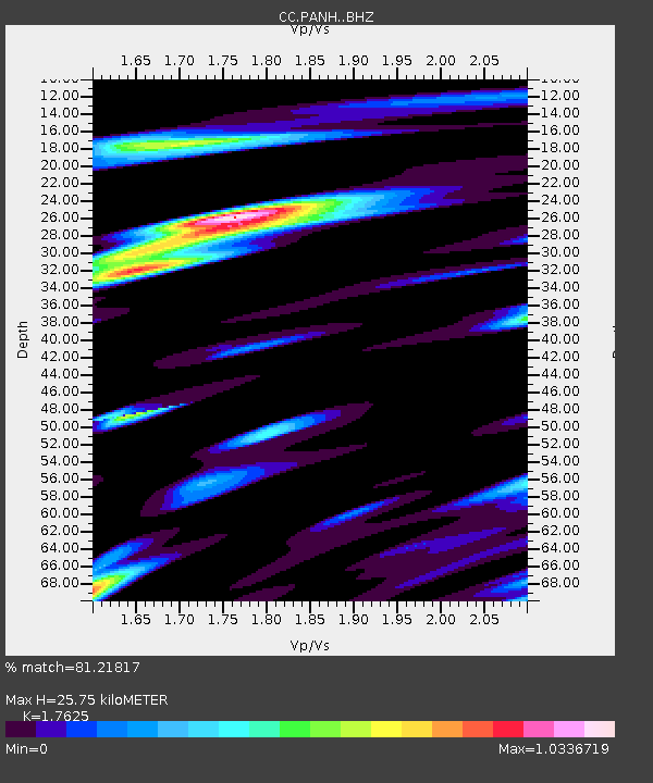
| Estimated Moho Depth: |
25.75 km |
| Estimated Crust Vp/Vs: |
1.76 |
| Assumed Crust Vp: |
6.597 km/s |
| Estimated Crust Vs: |
3.743 km/s |
| Estimated Crust Poisson's Ratio: |
0.26 |
|
| Radial Match: |
81.21817 % |
| Radial Bump: |
400 |
| Transverse Match: |
71.11377 % |
| Transverse Bump: |
400 |
| SOD ConfigId: |
31937991 |
| Insert Time: |
2023-09-15 20:58:35.922 +0000 |
| GWidth: |
2.5 |
| Max Bumps: |
400 |
| Tol: |
0.001 |
|

Signal To Noise
| Channel | StoN | STA | LTA |
| CC:PANH: :BHZ:20230901T20:58:15.860005Z | 7.80374 | 8.8374577E-7 | 1.1324644E-7 |
| CC:PANH: :BHN:20230901T20:58:15.860005Z | 3.568144 | 5.7425723E-7 | 1.6094003E-7 |
| CC:PANH: :BHE:20230901T20:58:15.860005Z | 3.1911595 | 4.8386113E-7 | 1.516255E-7 |
| Arrivals |
| Ps | 3.2 SECOND |
| PpPs | 10 SECOND |
| PsPs/PpSs | 13 SECOND |


