You are here: Home > Network List > CC - Cascade Chain Volcano Monitoring Stations List
> Station PR04 Puyallup River 04 > Earthquake Result Viewer
PR04 Puyallup River 04 - Earthquake Result Viewer
| Earthquake location: |
Kuril Islands |
| Earthquake latitude/longitude: |
50.7/156.3 |
| Earthquake time(UTC): |
2023/09/01 (244) 20:49:54 GMT |
| Earthquake Depth: |
141 km |
| Earthquake Magnitude: |
6.1 Mww |
| Earthquake Catalog/Contributor: |
NEIC PDE/us |
|
| Network: |
CC Cascade Chain Volcano Monitoring |
| Station: |
PR04 Puyallup River 04 |
| Lat/Lon: |
46.93 N/121.99 W |
| Elevation: |
908 m |
|
| Distance: |
51.3 deg |
| Az: |
60.309 deg |
| Baz: |
306.29 deg |
| Ray Param: |
0.067006394 |
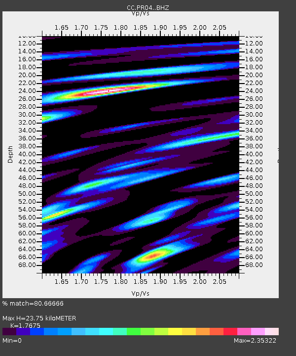
| Estimated Moho Depth: |
23.75 km |
| Estimated Crust Vp/Vs: |
1.77 |
| Assumed Crust Vp: |
6.597 km/s |
| Estimated Crust Vs: |
3.733 km/s |
| Estimated Crust Poisson's Ratio: |
0.26 |
|
| Radial Match: |
80.66666 % |
| Radial Bump: |
400 |
| Transverse Match: |
80.88853 % |
| Transverse Bump: |
400 |
| SOD ConfigId: |
31937991 |
| Insert Time: |
2023-09-15 20:58:42.915 +0000 |
| GWidth: |
2.5 |
| Max Bumps: |
400 |
| Tol: |
0.001 |
|

Signal To Noise
| Channel | StoN | STA | LTA |
| CC:PR04: :BHZ:20230901T20:58:14.140003Z | 7.099808 | 1.0873765E-6 | 1.5315575E-7 |
| CC:PR04: :BHN:20230901T20:58:14.140003Z | 2.691925 | 4.960038E-7 | 1.8425617E-7 |
| CC:PR04: :BHE:20230901T20:58:14.140003Z | 3.9853923 | 5.475285E-7 | 1.3738384E-7 |
| Arrivals |
| Ps | 2.9 SECOND |
| PpPs | 9.4 SECOND |
| PsPs/PpSs | 12 SECOND |


