You are here: Home > Network List > GB - Great Britain Seismograph Network Stations List
> Station HLM1 Long Mynd, Wales, UK > Earthquake Result Viewer
HLM1 Long Mynd, Wales, UK - Earthquake Result Viewer
| Earthquake location: |
Kuril Islands |
| Earthquake latitude/longitude: |
50.7/156.3 |
| Earthquake time(UTC): |
2023/09/01 (244) 20:49:54 GMT |
| Earthquake Depth: |
141 km |
| Earthquake Magnitude: |
6.1 Mww |
| Earthquake Catalog/Contributor: |
NEIC PDE/us |
|
| Network: |
GB Great Britain Seismograph Network |
| Station: |
HLM1 Long Mynd, Wales, UK |
| Lat/Lon: |
52.52 N/2.88 W |
| Elevation: |
429 m |
|
| Distance: |
75.7 deg |
| Az: |
347.055 deg |
| Baz: |
13.48 deg |
| Ray Param: |
0.051166397 |
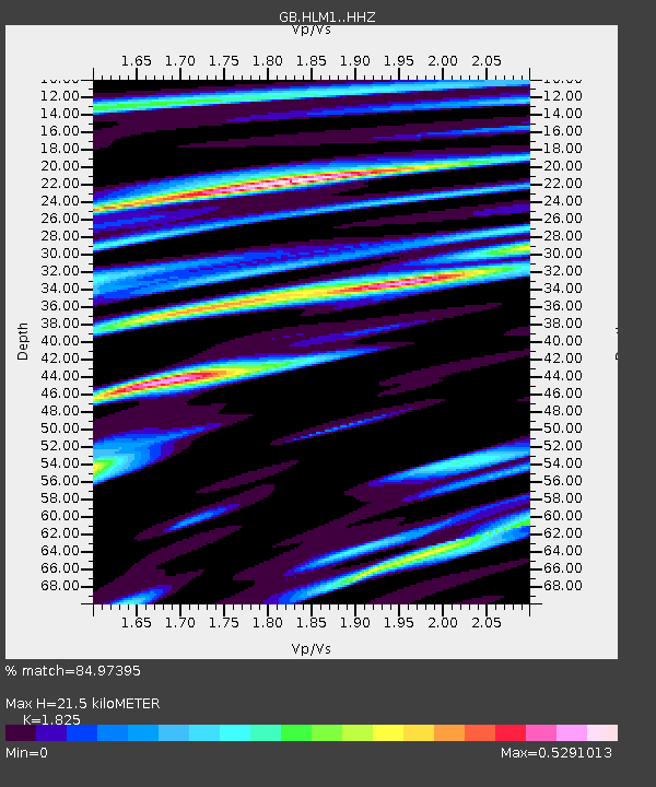
| Estimated Moho Depth: |
21.5 km |
| Estimated Crust Vp/Vs: |
1.83 |
| Assumed Crust Vp: |
6.276 km/s |
| Estimated Crust Vs: |
3.439 km/s |
| Estimated Crust Poisson's Ratio: |
0.29 |
|
| Radial Match: |
84.97395 % |
| Radial Bump: |
400 |
| Transverse Match: |
78.004974 % |
| Transverse Bump: |
400 |
| SOD ConfigId: |
31937991 |
| Insert Time: |
2023-09-15 21:06:01.336 +0000 |
| GWidth: |
2.5 |
| Max Bumps: |
400 |
| Tol: |
0.001 |
|

Signal To Noise
| Channel | StoN | STA | LTA |
| GB:HLM1: :HHZ:20230901T21:00:53.600025Z | 22.7438 | 4.1488274E-6 | 1.8241575E-7 |
| GB:HLM1: :HHN:20230901T21:00:53.600025Z | 10.471779 | 1.6103816E-6 | 1.5378299E-7 |
| GB:HLM1: :HHE:20230901T21:00:53.600025Z | 4.630756 | 6.209502E-7 | 1.3409262E-7 |
| Arrivals |
| Ps | 2.9 SECOND |
| PpPs | 9.4 SECOND |
| PsPs/PpSs | 12 SECOND |


