You are here: Home > Network List > HL - National Observatory of Athens Digital Broadband Network Stations List
> Station RDO RODHOPI, GREECE > Earthquake Result Viewer
RDO RODHOPI, GREECE - Earthquake Result Viewer
| Earthquake location: |
Kuril Islands |
| Earthquake latitude/longitude: |
50.7/156.3 |
| Earthquake time(UTC): |
2023/09/01 (244) 20:49:54 GMT |
| Earthquake Depth: |
141 km |
| Earthquake Magnitude: |
6.1 Mww |
| Earthquake Catalog/Contributor: |
NEIC PDE/us |
|
| Network: |
HL National Observatory of Athens Digital Broadband Network |
| Station: |
RDO RODHOPI, GREECE |
| Lat/Lon: |
41.15 N/25.54 E |
| Elevation: |
100 m |
|
| Distance: |
78.9 deg |
| Az: |
324.355 deg |
| Baz: |
29.385 deg |
| Ray Param: |
0.04898362 |
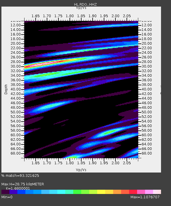
| Estimated Moho Depth: |
28.75 km |
| Estimated Crust Vp/Vs: |
1.68 |
| Assumed Crust Vp: |
6.279 km/s |
| Estimated Crust Vs: |
3.737 km/s |
| Estimated Crust Poisson's Ratio: |
0.23 |
|
| Radial Match: |
93.321625 % |
| Radial Bump: |
400 |
| Transverse Match: |
83.91394 % |
| Transverse Bump: |
400 |
| SOD ConfigId: |
31937991 |
| Insert Time: |
2023-09-15 21:08:31.746 +0000 |
| GWidth: |
2.5 |
| Max Bumps: |
400 |
| Tol: |
0.001 |
|

Signal To Noise
| Channel | StoN | STA | LTA |
| HL:RDO: :HHZ:20230901T21:01:11.689991Z | 104.52251 | 7.029617E-6 | 6.7254575E-8 |
| HL:RDO: :HHN:20230901T21:01:11.689991Z | 40.78052 | 2.849428E-6 | 6.987228E-8 |
| HL:RDO: :HHE:20230901T21:01:11.689991Z | 27.36047 | 1.938413E-6 | 7.0847214E-8 |
| Arrivals |
| Ps | 3.2 SECOND |
| PpPs | 12 SECOND |
| PsPs/PpSs | 15 SECOND |


