You are here: Home > Network List > IW - Intermountain West Stations List
> Station MOOW Moose Ponds, Wyoming, USA > Earthquake Result Viewer
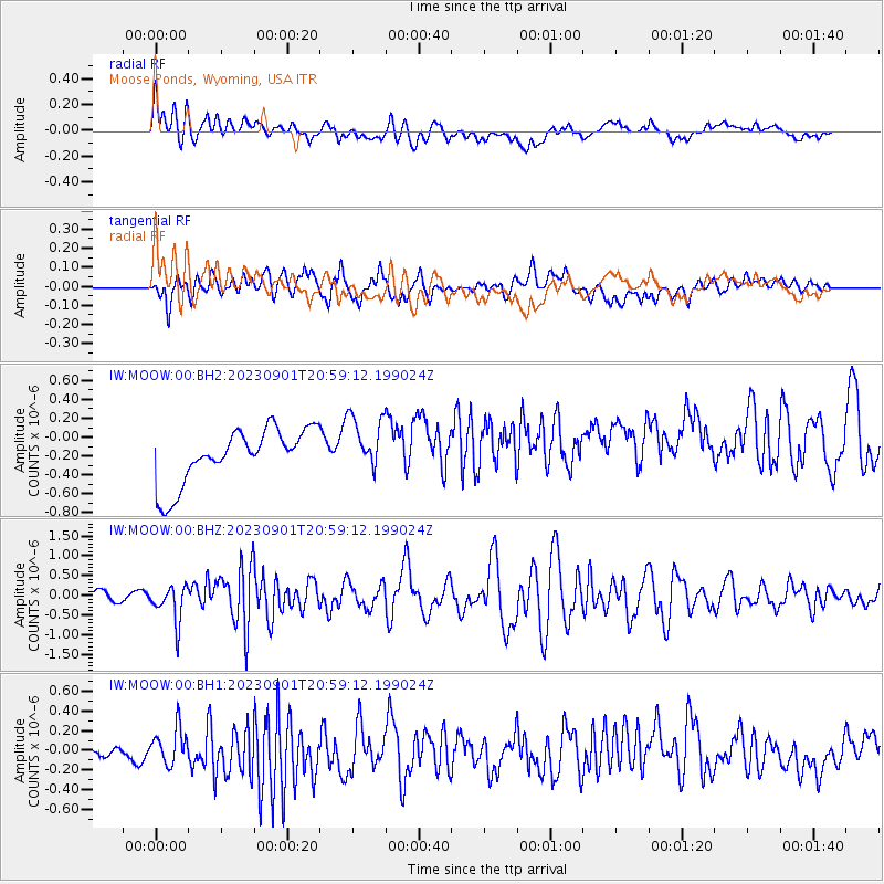
MOOW Moose Ponds, Wyoming, USA - Earthquake Result Viewer
*The percent match for this event was below the threshold and hence no stack was calculated.
| Earthquake location: |
Kuril Islands |
| Earthquake latitude/longitude: |
50.7/156.3 |
| Earthquake time(UTC): |
2023/09/01 (244) 20:49:54 GMT |
| Earthquake Depth: |
141 km |
| Earthquake Magnitude: |
6.1 Mww |
| Earthquake Catalog/Contributor: |
NEIC PDE/us |
|
| Network: |
IW Intermountain West |
| Station: |
MOOW Moose Ponds, Wyoming, USA |
| Lat/Lon: |
43.75 N/110.74 W |
| Elevation: |
2128 m |
|
| Distance: |
59.5 deg |
| Az: |
57.176 deg |
| Baz: |
312.493 deg |
| Ray Param: |
$rayparam |
*The percent match for this event was below the threshold and hence was not used in the summary stack. |
|
| Radial Match: |
45.08732 % |
| Radial Bump: |
400 |
| Transverse Match: |
63.88377 % |
| Transverse Bump: |
400 |
| SOD ConfigId: |
31937991 |
| Insert Time: |
2023-09-15 21:10:48.005 +0000 |
| GWidth: |
2.5 |
| Max Bumps: |
400 |
| Tol: |
0.001 |
|
Signal To Noise
| Channel | StoN | STA | LTA |
| IW:MOOW:00:BHZ:20230901T20:59:12.199024Z | 4.469553 | 4.6422957E-7 | 1.0386488E-7 |
| IW:MOOW:00:BH1:20230901T20:59:12.199024Z | 1.0997682 | 1.9903626E-7 | 1.809802E-7 |
| IW:MOOW:00:BH2:20230901T20:59:12.199024Z | 1.0530024 | 3.04287E-7 | 2.8897085E-7 |
| Arrivals |
| Ps | |
| PpPs | |
| PsPs/PpSs | |


