You are here: Home > Network List > G - GEOSCOPE Stations List
> Station TAOE Taiohae, Marquises islands > Earthquake Result Viewer
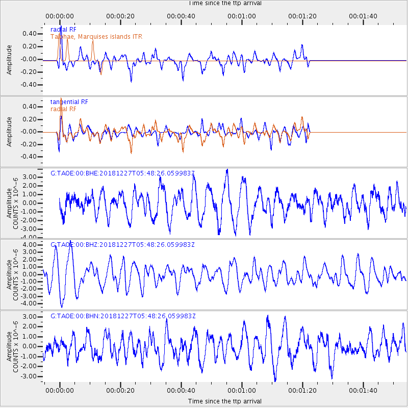
TAOE Taiohae, Marquises islands - Earthquake Result Viewer
*The percent match for this event was below the threshold and hence no stack was calculated.
| Earthquake location: |
Solomon Islands |
| Earthquake latitude/longitude: |
-10.1/161.1 |
| Earthquake time(UTC): |
2018/12/27 (361) 05:39:12 GMT |
| Earthquake Depth: |
71 km |
| Earthquake Magnitude: |
5.4 Mww |
| Earthquake Catalog/Contributor: |
NEIC PDE/us |
|
| Network: |
G GEOSCOPE |
| Station: |
TAOE Taiohae, Marquises islands |
| Lat/Lon: |
8.85 S/140.15 W |
| Elevation: |
800 m |
|
| Distance: |
57.9 deg |
| Az: |
94.157 deg |
| Baz: |
263.656 deg |
| Ray Param: |
$rayparam |
*The percent match for this event was below the threshold and hence was not used in the summary stack. |
|
| Radial Match: |
61.12611 % |
| Radial Bump: |
400 |
| Transverse Match: |
45.41967 % |
| Transverse Bump: |
400 |
| SOD ConfigId: |
3201911 |
| Insert Time: |
2019-01-10 05:54:53.644 +0000 |
| GWidth: |
2.5 |
| Max Bumps: |
400 |
| Tol: |
0.001 |
|
Signal To Noise
| Channel | StoN | STA | LTA |
| G:TAOE:00:BHZ:20181227T05:48:26.059983Z | 2.9399512 | 2.9783398E-6 | 1.0130576E-6 |
| G:TAOE:00:BHN:20181227T05:48:26.059983Z | 0.6306045 | 7.463672E-7 | 1.1835742E-6 |
| G:TAOE:00:BHE:20181227T05:48:26.059983Z | 1.5715799 | 1.7603192E-6 | 1.1200952E-6 |
| Arrivals |
| Ps | |
| PpPs | |
| PsPs/PpSs | |


