You are here: Home > Network List > TA - USArray Transportable Network (new EarthScope stations) Stations List
> Station C20A Veseth Ranch, Zortman, MT, USA > Earthquake Result Viewer
C20A Veseth Ranch, Zortman, MT, USA - Earthquake Result Viewer
| Earthquake location: |
Andreanof Islands, Aleutian Is. |
| Earthquake latitude/longitude: |
51.8/-176.1 |
| Earthquake time(UTC): |
2010/07/14 (195) 11:01:27 GMT |
| Earthquake Depth: |
51 km |
| Earthquake Magnitude: |
5.6 MB, 5.6 MW, 4.9 ML |
| Earthquake Catalog/Contributor: |
WHDF/NEIC |
|
| Network: |
TA USArray Transportable Network (new EarthScope stations) |
| Station: |
C20A Veseth Ranch, Zortman, MT, USA |
| Lat/Lon: |
47.71 N/108.00 W |
| Elevation: |
781 m |
|
| Distance: |
42.7 deg |
| Az: |
67.427 deg |
| Baz: |
301.909 deg |
| Ray Param: |
0.072861776 |
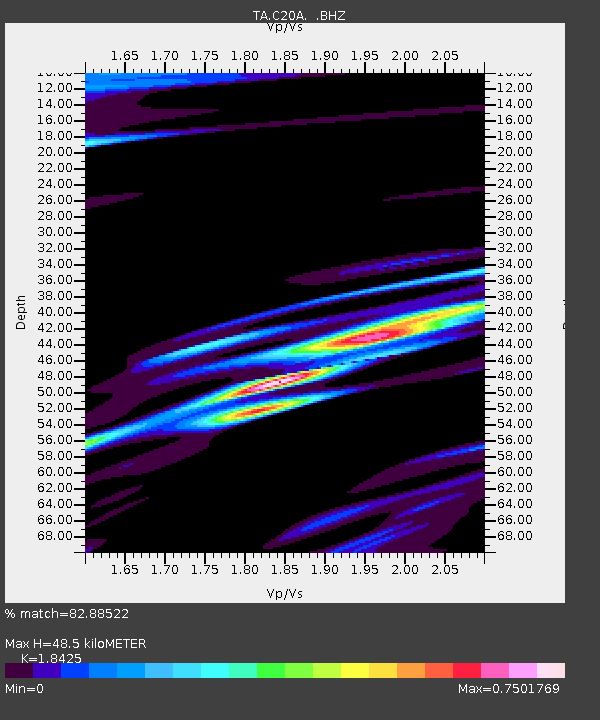
| Estimated Moho Depth: |
48.5 km |
| Estimated Crust Vp/Vs: |
1.84 |
| Assumed Crust Vp: |
6.518 km/s |
| Estimated Crust Vs: |
3.538 km/s |
| Estimated Crust Poisson's Ratio: |
0.29 |
|
| Radial Match: |
82.88522 % |
| Radial Bump: |
400 |
| Transverse Match: |
67.23193 % |
| Transverse Bump: |
400 |
| SOD ConfigId: |
319893 |
| Insert Time: |
2011-01-05 03:45:52.425 +0000 |
| GWidth: |
2.5 |
| Max Bumps: |
400 |
| Tol: |
0.001 |
|

Signal To Noise
| Channel | StoN | STA | LTA |
| TA:C20A: :BHZ:20100714T11:08:49.049998Z | 2.8521395 | 9.980134E-7 | 3.4991749E-7 |
| TA:C20A: :BHN:20100714T11:08:49.049998Z | 2.418048 | 5.7602057E-7 | 2.3821718E-7 |
| TA:C20A: :BHE:20100714T11:08:49.049998Z | 1.3323982 | 5.473799E-7 | 4.1082305E-7 |
| Arrivals |
| Ps | 6.7 SECOND |
| PpPs | 20 SECOND |
| PsPs/PpSs | 26 SECOND |


