You are here: Home > Network List > SC - New Mexico Tech Seismic Network Stations List
> Station CL7 WIPP Site, New Mexico > Earthquake Result Viewer
CL7 WIPP Site, New Mexico - Earthquake Result Viewer
| Earthquake location: |
Kuril Islands |
| Earthquake latitude/longitude: |
50.7/156.3 |
| Earthquake time(UTC): |
2023/09/01 (244) 20:49:54 GMT |
| Earthquake Depth: |
141 km |
| Earthquake Magnitude: |
6.1 Mww |
| Earthquake Catalog/Contributor: |
NEIC PDE/us |
|
| Network: |
SC New Mexico Tech Seismic Network |
| Station: |
CL7 WIPP Site, New Mexico |
| Lat/Lon: |
32.41 N/103.81 W |
| Elevation: |
1034 m |
|
| Distance: |
71.4 deg |
| Az: |
61.567 deg |
| Baz: |
318.615 deg |
| Ray Param: |
0.054012023 |
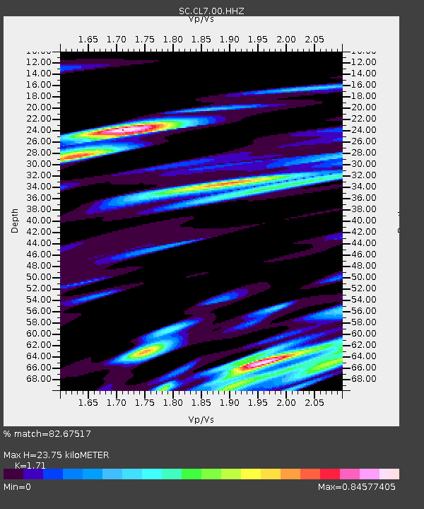
| Estimated Moho Depth: |
23.75 km |
| Estimated Crust Vp/Vs: |
1.71 |
| Assumed Crust Vp: |
6.129 km/s |
| Estimated Crust Vs: |
3.584 km/s |
| Estimated Crust Poisson's Ratio: |
0.24 |
|
| Radial Match: |
82.67517 % |
| Radial Bump: |
400 |
| Transverse Match: |
67.55233 % |
| Transverse Bump: |
400 |
| SOD ConfigId: |
31937991 |
| Insert Time: |
2023-09-15 21:22:29.918 +0000 |
| GWidth: |
2.5 |
| Max Bumps: |
400 |
| Tol: |
0.001 |
|

Signal To Noise
| Channel | StoN | STA | LTA |
| SC:CL7:00:HHZ:20230901T21:00:28.595021Z | 11.886177 | 1.4528435E-7 | 1.22229675E-8 |
| SC:CL7:00:HHN:20230901T21:00:28.595021Z | 1.8897702 | 3.884421E-8 | 2.055499E-8 |
| SC:CL7:00:HHE:20230901T21:00:28.595021Z | 1.9219451 | 4.6137018E-8 | 2.4005377E-8 |
| Arrivals |
| Ps | 2.8 SECOND |
| PpPs | 10 SECOND |
| PsPs/PpSs | 13 SECOND |


