You are here: Home > Network List > TM - Thai Seismic Monitoring Network Stations List
> Station PANO PANO staion > Earthquake Result Viewer
PANO PANO staion - Earthquake Result Viewer
| Earthquake location: |
Kuril Islands |
| Earthquake latitude/longitude: |
50.7/156.3 |
| Earthquake time(UTC): |
2023/09/01 (244) 20:49:54 GMT |
| Earthquake Depth: |
141 km |
| Earthquake Magnitude: |
6.1 Mww |
| Earthquake Catalog/Contributor: |
NEIC PDE/us |
|
| Network: |
TM Thai Seismic Monitoring Network |
| Station: |
PANO PANO staion |
| Lat/Lon: |
17.15 N/104.61 E |
| Elevation: |
136 m |
|
| Distance: |
52.9 deg |
| Az: |
250.145 deg |
| Baz: |
38.723 deg |
| Ray Param: |
0.06597424 |
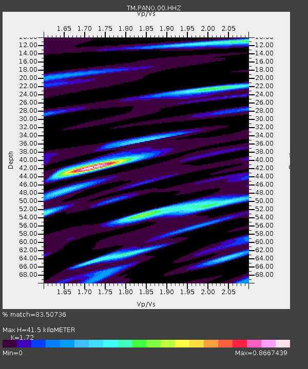
| Estimated Moho Depth: |
41.5 km |
| Estimated Crust Vp/Vs: |
1.72 |
| Assumed Crust Vp: |
6.498 km/s |
| Estimated Crust Vs: |
3.778 km/s |
| Estimated Crust Poisson's Ratio: |
0.24 |
|
| Radial Match: |
83.50736 % |
| Radial Bump: |
400 |
| Transverse Match: |
78.16809 % |
| Transverse Bump: |
400 |
| SOD ConfigId: |
31937991 |
| Insert Time: |
2023-09-15 21:23:17.483 +0000 |
| GWidth: |
2.5 |
| Max Bumps: |
400 |
| Tol: |
0.001 |
|

Signal To Noise
| Channel | StoN | STA | LTA |
| TM:PANO:00:HHZ:20230901T20:58:25.920002Z | 31.436956 | 9.0548684E-7 | 2.8803262E-8 |
| TM:PANO:00:HHN:20230901T20:58:25.920002Z | 6.0945454 | 1.6916712E-7 | 2.7757137E-8 |
| TM:PANO:00:HHE:20230901T20:58:25.920002Z | 0.70858216 | 2.1685615E-8 | 3.0604234E-8 |
| Arrivals |
| Ps | 4.9 SECOND |
| PpPs | 16 SECOND |
| PsPs/PpSs | 21 SECOND |


