You are here: Home > Network List > TX - Texas Seismological Network Stations List
> Station PB16 Coyonosa > Earthquake Result Viewer
PB16 Coyonosa - Earthquake Result Viewer
| Earthquake location: |
Kuril Islands |
| Earthquake latitude/longitude: |
50.7/156.3 |
| Earthquake time(UTC): |
2023/09/01 (244) 20:49:54 GMT |
| Earthquake Depth: |
141 km |
| Earthquake Magnitude: |
6.1 Mww |
| Earthquake Catalog/Contributor: |
NEIC PDE/us |
|
| Network: |
TX Texas Seismological Network |
| Station: |
PB16 Coyonosa |
| Lat/Lon: |
31.12 N/103.25 W |
| Elevation: |
848 m |
|
| Distance: |
72.6 deg |
| Az: |
62.081 deg |
| Baz: |
319.065 deg |
| Ray Param: |
0.053167913 |
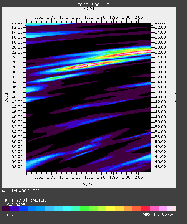
| Estimated Moho Depth: |
27.0 km |
| Estimated Crust Vp/Vs: |
1.84 |
| Assumed Crust Vp: |
6.121 km/s |
| Estimated Crust Vs: |
3.322 km/s |
| Estimated Crust Poisson's Ratio: |
0.29 |
|
| Radial Match: |
80.11921 % |
| Radial Bump: |
400 |
| Transverse Match: |
60.93121 % |
| Transverse Bump: |
400 |
| SOD ConfigId: |
31937991 |
| Insert Time: |
2023-09-15 21:24:30.283 +0000 |
| GWidth: |
2.5 |
| Max Bumps: |
400 |
| Tol: |
0.001 |
|

Signal To Noise
| Channel | StoN | STA | LTA |
| TX:PB16:00:HHZ:20230901T21:00:36.189991Z | 3.176316 | 9.0440193E-7 | 2.84733E-7 |
| TX:PB16:00:HH1:20230901T21:00:36.189991Z | 1.0830007 | 2.8969572E-7 | 2.674936E-7 |
| TX:PB16:00:HH2:20230901T21:00:36.189991Z | 1.2265611 | 2.5263455E-7 | 2.059698E-7 |
| Arrivals |
| Ps | 3.8 SECOND |
| PpPs | 12 SECOND |
| PsPs/PpSs | 16 SECOND |


