You are here: Home > Network List > TA - USArray Transportable Network (new EarthScope stations) Stations List
> Station G24A Alzada, MT, USA > Earthquake Result Viewer
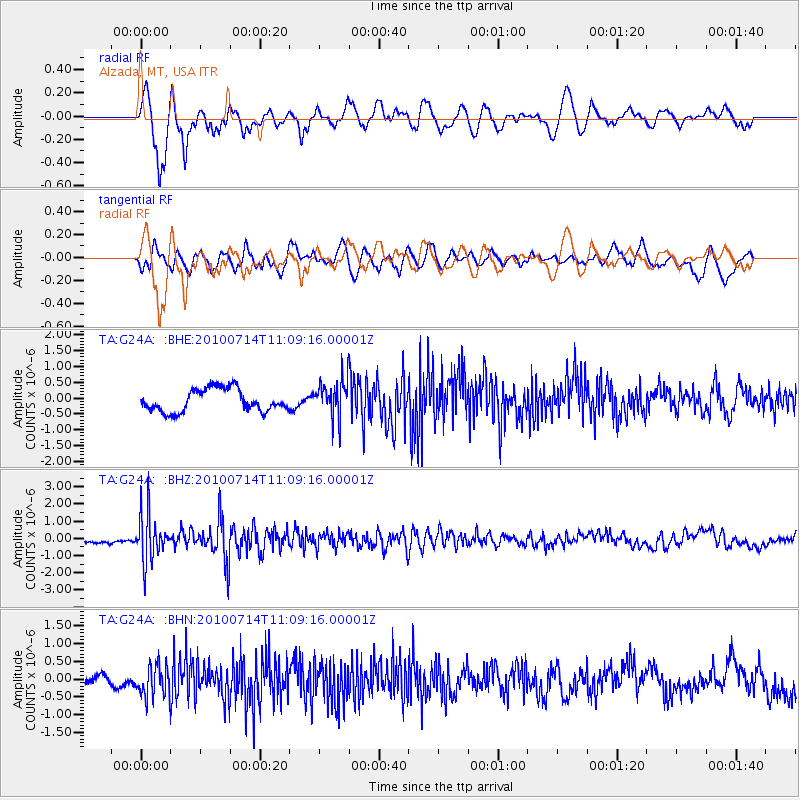
G24A Alzada, MT, USA - Earthquake Result Viewer
*The percent match for this event was below the threshold and hence no stack was calculated.
| Earthquake location: |
Andreanof Islands, Aleutian Is. |
| Earthquake latitude/longitude: |
51.8/-176.1 |
| Earthquake time(UTC): |
2010/07/14 (195) 11:01:27 GMT |
| Earthquake Depth: |
51 km |
| Earthquake Magnitude: |
5.6 MB, 5.6 MW, 4.9 ML |
| Earthquake Catalog/Contributor: |
WHDF/NEIC |
|
| Network: |
TA USArray Transportable Network (new EarthScope stations) |
| Station: |
G24A Alzada, MT, USA |
| Lat/Lon: |
45.33 N/104.42 W |
| Elevation: |
1147 m |
|
| Distance: |
46.1 deg |
| Az: |
68.313 deg |
| Baz: |
305.138 deg |
| Ray Param: |
$rayparam |
*The percent match for this event was below the threshold and hence was not used in the summary stack. |
|
| Radial Match: |
78.191246 % |
| Radial Bump: |
400 |
| Transverse Match: |
55.463383 % |
| Transverse Bump: |
400 |
| SOD ConfigId: |
319893 |
| Insert Time: |
2011-01-05 03:49:09.126 +0000 |
| GWidth: |
2.5 |
| Max Bumps: |
400 |
| Tol: |
0.001 |
|
Signal To Noise
| Channel | StoN | STA | LTA |
| TA:G24A: :BHZ:20100714T11:09:16.00001Z | 4.335794 | 1.3370294E-6 | 3.0837015E-7 |
| TA:G24A: :BHN:20100714T11:09:16.00001Z | 3.9201899 | 4.3292863E-7 | 1.1043563E-7 |
| TA:G24A: :BHE:20100714T11:09:16.00001Z | 1.6863205 | 5.977782E-7 | 3.544867E-7 |
| Arrivals |
| Ps | |
| PpPs | |
| PsPs/PpSs | |


