You are here: Home > Network List > UU - University of Utah Regional Network Stations List
> Station FSB1 FORGE surface borehole 1, UT, USA > Earthquake Result Viewer
FSB1 FORGE surface borehole 1, UT, USA - Earthquake Result Viewer
| Earthquake location: |
Kuril Islands |
| Earthquake latitude/longitude: |
50.7/156.3 |
| Earthquake time(UTC): |
2023/09/01 (244) 20:49:54 GMT |
| Earthquake Depth: |
141 km |
| Earthquake Magnitude: |
6.1 Mww |
| Earthquake Catalog/Contributor: |
NEIC PDE/us |
|
| Network: |
UU University of Utah Regional Network |
| Station: |
FSB1 FORGE surface borehole 1, UT, USA |
| Lat/Lon: |
38.48 N/112.89 W |
| Elevation: |
1697 m |
|
| Distance: |
61.9 deg |
| Az: |
62.848 deg |
| Baz: |
313.866 deg |
| Ray Param: |
0.060177393 |
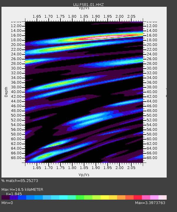
| Estimated Moho Depth: |
16.5 km |
| Estimated Crust Vp/Vs: |
1.95 |
| Assumed Crust Vp: |
6.276 km/s |
| Estimated Crust Vs: |
3.227 km/s |
| Estimated Crust Poisson's Ratio: |
0.32 |
|
| Radial Match: |
85.25273 % |
| Radial Bump: |
400 |
| Transverse Match: |
72.96546 % |
| Transverse Bump: |
400 |
| SOD ConfigId: |
31937991 |
| Insert Time: |
2023-09-15 21:28:39.876 +0000 |
| GWidth: |
2.5 |
| Max Bumps: |
400 |
| Tol: |
0.001 |
|

Signal To Noise
| Channel | StoN | STA | LTA |
| UU:FSB1:01:HHZ:20230901T20:59:28.525013Z | 2.8807855 | 9.385492E-7 | 3.2579626E-7 |
| UU:FSB1:01:HH1:20230901T20:59:28.525013Z | 2.4999785 | 8.1497586E-7 | 3.2599314E-7 |
| UU:FSB1:01:HH2:20230901T20:59:28.525013Z | 3.2115657 | 9.731374E-7 | 3.0301027E-7 |
| Arrivals |
| Ps | 2.6 SECOND |
| PpPs | 7.5 SECOND |
| PsPs/PpSs | 10 SECOND |


