You are here: Home > Network List > UU - University of Utah Regional Network Stations List
> Station FSB4 FORGE surface borehole 4, UT, USA > Earthquake Result Viewer
FSB4 FORGE surface borehole 4, UT, USA - Earthquake Result Viewer
| Earthquake location: |
Kuril Islands |
| Earthquake latitude/longitude: |
50.7/156.3 |
| Earthquake time(UTC): |
2023/09/01 (244) 20:49:54 GMT |
| Earthquake Depth: |
141 km |
| Earthquake Magnitude: |
6.1 Mww |
| Earthquake Catalog/Contributor: |
NEIC PDE/us |
|
| Network: |
UU University of Utah Regional Network |
| Station: |
FSB4 FORGE surface borehole 4, UT, USA |
| Lat/Lon: |
38.43 N/112.93 W |
| Elevation: |
1578 m |
|
| Distance: |
61.9 deg |
| Az: |
62.922 deg |
| Baz: |
313.875 deg |
| Ray Param: |
0.060165886 |
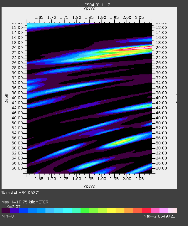
| Estimated Moho Depth: |
19.75 km |
| Estimated Crust Vp/Vs: |
2.07 |
| Assumed Crust Vp: |
6.276 km/s |
| Estimated Crust Vs: |
3.032 km/s |
| Estimated Crust Poisson's Ratio: |
0.35 |
|
| Radial Match: |
80.05371 % |
| Radial Bump: |
400 |
| Transverse Match: |
77.409744 % |
| Transverse Bump: |
400 |
| SOD ConfigId: |
31937991 |
| Insert Time: |
2023-09-15 21:28:44.264 +0000 |
| GWidth: |
2.5 |
| Max Bumps: |
400 |
| Tol: |
0.001 |
|

Signal To Noise
| Channel | StoN | STA | LTA |
| UU:FSB4:01:HHZ:20230901T20:59:28.634999Z | 5.3978662 | 1.0502807E-6 | 1.9457333E-7 |
| UU:FSB4:01:HH1:20230901T20:59:28.634999Z | 1.608736 | 4.704131E-7 | 2.924116E-7 |
| UU:FSB4:01:HH2:20230901T20:59:28.634999Z | 3.0557413 | 1.2453336E-6 | 4.0753895E-7 |
| Arrivals |
| Ps | 3.5 SECOND |
| PpPs | 9.3 SECOND |
| PsPs/PpSs | 13 SECOND |


