You are here: Home > Network List > TA - USArray Transportable Network (new EarthScope stations) Stations List
> Station N30A Hueftle Ranch, Cozad, NE, USA > Earthquake Result Viewer
N30A Hueftle Ranch, Cozad, NE, USA - Earthquake Result Viewer
| Earthquake location: |
Andreanof Islands, Aleutian Is. |
| Earthquake latitude/longitude: |
51.8/-176.1 |
| Earthquake time(UTC): |
2010/07/14 (195) 11:01:27 GMT |
| Earthquake Depth: |
51 km |
| Earthquake Magnitude: |
5.6 MB, 5.6 MW, 4.9 ML |
| Earthquake Catalog/Contributor: |
WHDF/NEIC |
|
| Network: |
TA USArray Transportable Network (new EarthScope stations) |
| Station: |
N30A Hueftle Ranch, Cozad, NE, USA |
| Lat/Lon: |
40.80 N/100.10 W |
| Elevation: |
842 m |
|
| Distance: |
51.4 deg |
| Az: |
70.547 deg |
| Baz: |
309.553 deg |
| Ray Param: |
0.06732467 |
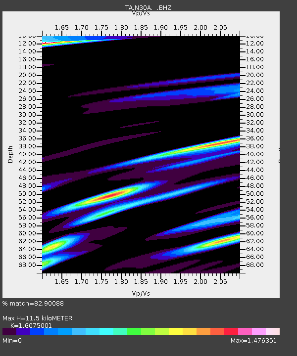
| Estimated Moho Depth: |
11.5 km |
| Estimated Crust Vp/Vs: |
1.61 |
| Assumed Crust Vp: |
6.483 km/s |
| Estimated Crust Vs: |
4.033 km/s |
| Estimated Crust Poisson's Ratio: |
0.18 |
|
| Radial Match: |
82.90088 % |
| Radial Bump: |
400 |
| Transverse Match: |
67.388336 % |
| Transverse Bump: |
400 |
| SOD ConfigId: |
319893 |
| Insert Time: |
2011-01-05 03:52:23.551 +0000 |
| GWidth: |
2.5 |
| Max Bumps: |
400 |
| Tol: |
0.001 |
|
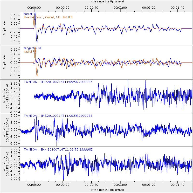
Signal To Noise
| Channel | StoN | STA | LTA |
| TA:N30A: :BHZ:20100714T11:09:56.299998Z | 3.8461578 | 8.0944267E-7 | 2.1045489E-7 |
| TA:N30A: :BHN:20100714T11:09:56.299998Z | 1.3329498 | 3.2815936E-7 | 2.4619033E-7 |
| TA:N30A: :BHE:20100714T11:09:56.299998Z | 2.0532322 | 4.443727E-7 | 2.1642592E-7 |
| Arrivals |
| Ps | 1.1 SECOND |
| PpPs | 4.3 SECOND |
| PsPs/PpSs | 5.5 SECOND |


