You are here: Home > Network List > IU - Global Seismograph Network (GSN - IRIS/USGS) Stations List
> Station WVT Waverly, Tennessee, USA > Earthquake Result Viewer
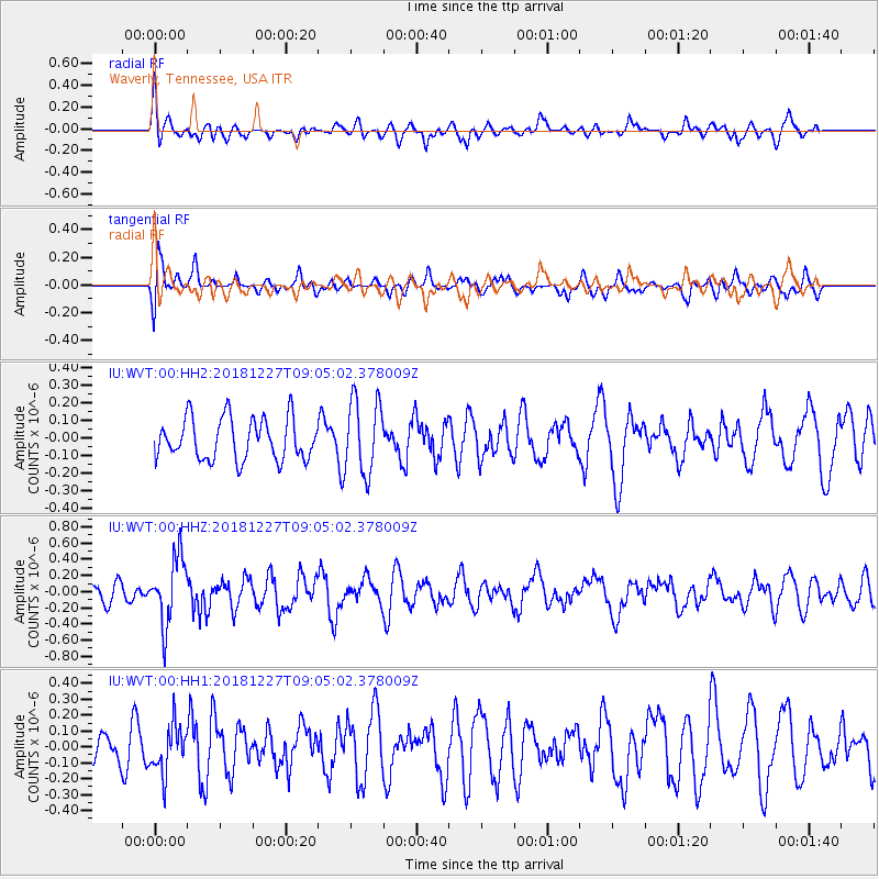
WVT Waverly, Tennessee, USA - Earthquake Result Viewer
*The percent match for this event was below the threshold and hence no stack was calculated.
| Earthquake location: |
Near Coast Of Venezuela |
| Earthquake latitude/longitude: |
10.3/-67.9 |
| Earthquake time(UTC): |
2018/12/27 (361) 08:59:11 GMT |
| Earthquake Depth: |
10 km |
| Earthquake Magnitude: |
5.6 Mww |
| Earthquake Catalog/Contributor: |
NEIC PDE/us |
|
| Network: |
IU Global Seismograph Network (GSN - IRIS/USGS) |
| Station: |
WVT Waverly, Tennessee, USA |
| Lat/Lon: |
36.13 N/87.83 W |
| Elevation: |
170 m |
|
| Distance: |
31.4 deg |
| Az: |
328.084 deg |
| Baz: |
140.008 deg |
| Ray Param: |
$rayparam |
*The percent match for this event was below the threshold and hence was not used in the summary stack. |
|
| Radial Match: |
56.03861 % |
| Radial Bump: |
400 |
| Transverse Match: |
48.29762 % |
| Transverse Bump: |
400 |
| SOD ConfigId: |
3201911 |
| Insert Time: |
2019-01-10 09:16:03.101 +0000 |
| GWidth: |
2.5 |
| Max Bumps: |
400 |
| Tol: |
0.001 |
|
Signal To Noise
| Channel | StoN | STA | LTA |
| IU:WVT:00:HHZ:20181227T09:05:02.378009Z | 2.4325078 | 4.118089E-7 | 1.6929398E-7 |
| IU:WVT:00:HH1:20181227T09:05:02.378009Z | 1.5665157 | 1.5156192E-7 | 9.675097E-8 |
| IU:WVT:00:HH2:20181227T09:05:02.378009Z | 1.8128494 | 2.1138916E-7 | 1.16606024E-7 |
| Arrivals |
| Ps | |
| PpPs | |
| PsPs/PpSs | |


