You are here: Home > Network List > TA - USArray Transportable Network (new EarthScope stations) Stations List
> Station J25A Sunshine Ranch, Edgemont, SD, USA > Earthquake Result Viewer
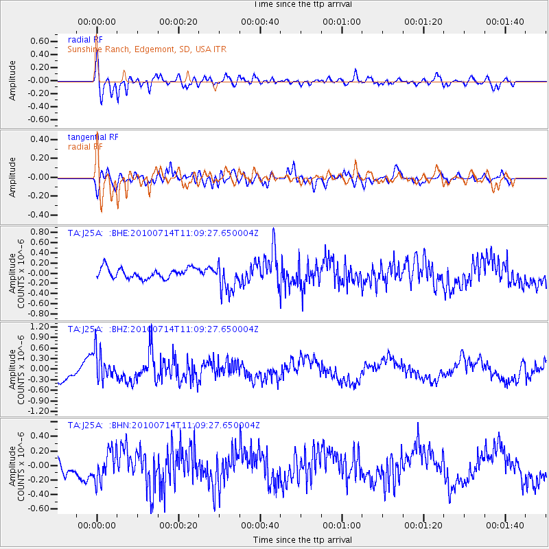
J25A Sunshine Ranch, Edgemont, SD, USA - Earthquake Result Viewer
| Earthquake location: |
Andreanof Islands, Aleutian Is. |
| Earthquake latitude/longitude: |
51.8/-176.1 |
| Earthquake time(UTC): |
2010/07/14 (195) 11:01:27 GMT |
| Earthquake Depth: |
51 km |
| Earthquake Magnitude: |
5.6 MB, 5.6 MW, 4.9 ML |
| Earthquake Catalog/Contributor: |
WHDF/NEIC |
|
| Network: |
TA USArray Transportable Network (new EarthScope stations) |
| Station: |
J25A Sunshine Ranch, Edgemont, SD, USA |
| Lat/Lon: |
43.39 N/103.80 W |
| Elevation: |
1220 m |
|
| Distance: |
47.6 deg |
| Az: |
70.107 deg |
| Baz: |
306.793 deg |
| Ray Param: |
0.06974957 |
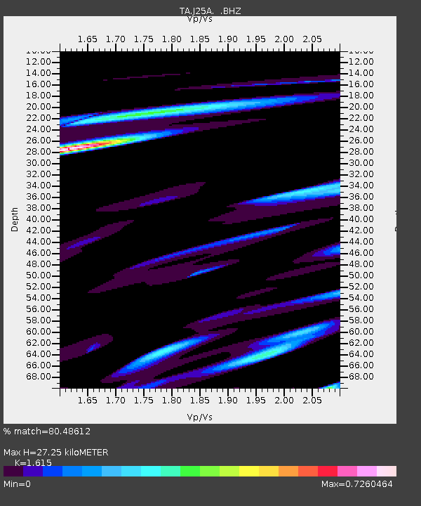
| Estimated Moho Depth: |
27.25 km |
| Estimated Crust Vp/Vs: |
1.62 |
| Assumed Crust Vp: |
6.483 km/s |
| Estimated Crust Vs: |
4.014 km/s |
| Estimated Crust Poisson's Ratio: |
0.19 |
|
| Radial Match: |
80.48612 % |
| Radial Bump: |
400 |
| Transverse Match: |
72.316574 % |
| Transverse Bump: |
400 |
| SOD ConfigId: |
319893 |
| Insert Time: |
2011-01-05 03:53:01.042 +0000 |
| GWidth: |
2.5 |
| Max Bumps: |
400 |
| Tol: |
0.001 |
|
Signal To Noise
| Channel | StoN | STA | LTA |
| TA:J25A: :BHZ:20100714T11:09:27.650004Z | 1.4495881 | 4.3129458E-7 | 2.9752906E-7 |
| TA:J25A: :BHN:20100714T11:09:27.650004Z | 1.4759796 | 2.0660278E-7 | 1.3997672E-7 |
| TA:J25A: :BHE:20100714T11:09:27.650004Z | 2.8904417 | 2.8626843E-7 | 9.903968E-8 |
| Arrivals |
| Ps | 2.8 SECOND |
| PpPs | 10 SECOND |
| PsPs/PpSs | 13 SECOND |


